Quotulatiousness

October 13, 2011

The 14th Amendment, a history

Filed under: Government, History, Law, Liberty — Tags: , , , — Nicholas @ 09:54

March 26, 2011

550th anniversary of the bloodiest battle in English history

Filed under: Britain, History — Tags: , , , , — Nicholas @ 00:07

Unless you were paying close attention in your history classes, you probably wouldn’t recognize the name:

It was one of the biggest and probably the bloodiest battle ever fought on British soil. Such was its ferocity almost 1 per cent of the English population was wiped out in a single day. Yet mention the Battle of Towton to most people and you would probably get a blank stare.

Next week marks the 550th anniversary of the engagement that changed the course of the Wars of the Roses. It is estimated that between 50,000 and 80,000 soldiers took part in the battle in 1461 between the Houses of York and Lancaster for control of the English throne. An estimated 28,000 men are said to have lost their lives.

But this bloody conflict is unlikely to remain forgotten for much longer. Archaeologists believe they will unearth what is likely to be Britain’s largest mass grave this summer.

Work is to begin in June, at a site 12 miles south of York between the villages of Saxton and Towton where the battle took place in snowy March weather. The locations of the graves were discovered by archaeologists using geophysical imagery and now, with funding in place, they are able to begin excavating.

And why is such a major battle so little-known? Perhaps because the “wrong” side won:

Very few records of the battle survive, which is one reason that so little is known about it. Historians believe this could be due to an early propaganda campaign by the Tudors.

Author and historian George Goodwin, who this month publishes a new book: Fatal Colours: Towton, 1461 — England’s Most Brutal Battle, said: “The Tudors did a tremendously good propaganda job in making Bosworth the key battle because that was the battle which ended the Wars of the Roses. They were the winners and they got to write the history books. Because Towton was a Yorkist victory that wasn’t really very useful to them.”

December 30, 2010

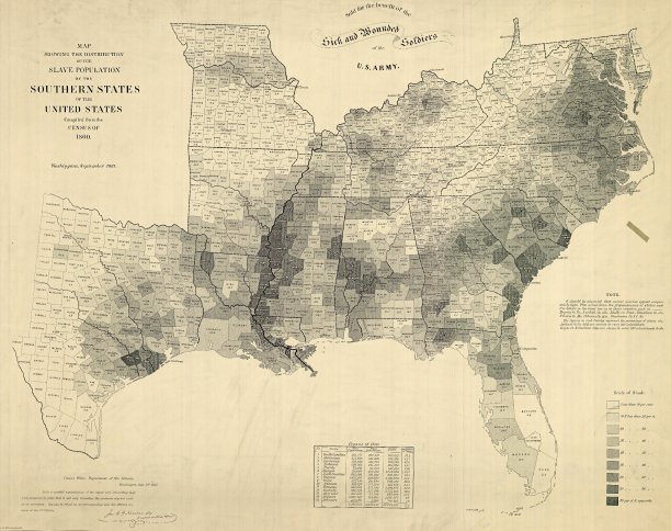
Cartographic explanation for the order of secession

Filed under: History, USA — Tags: , , , — Nicholas @ 00:20

A fascinating NYT post looks at one of the most influential maps of the US Civil War period:

The 1860 Census was the last time the federal government took a count of the South’s vast slave population. Several months later, the United States Coast Survey — arguably the most important scientific agency in the nation at the time — issued two maps of slavery that drew on the Census data, the first of Virginia and the second of Southern states as a whole. Though many Americans knew that dependence on slave labor varied throughout the South, these maps uniquely captured the complexity of the institution and struck a chord with a public hungry for information about the rebellion.

The map uses what was then a new technique in statistical cartography: Each county not only displays its slave population numerically, but is shaded (the darker the shading, the higher the number of slaves) to visualize the concentration of slavery across the region. The counties along the Mississippi River and in coastal South Carolina are almost black, while Kentucky and the Appalachians are nearly white.

H/T to Walter Olson for the link.

« Newer Posts

Powered by WordPress