
The Second World War witnessed two concurrent campaigns by which submarines were used in an attempt to economically isolate and degrade an island nation enemy. One of these attempts was remarkably successful. In the Pacific, US Submariners sunk millions of tons of Japanese shipping — more shipping, in fact, than Japan had possessed at the outbreak of war. A brutally effective submarine campaign against Japanese tankers affected a near perfect starvation of Japan’s war machine: after intaking 40% of East Indies crude production in 1942, only 5% would reach Japanese shores in 1944. This was a cataclysmic decline which Japan could not survive, owed largely to the 155 tankers sunk by American submarines in 1943 and 1944. In the final year of the war, American boats were able to undertake the ultimate dream of submarine theorists: a close blockade of the Japanese home islands, with American submariners prowling practically every inlet and bay.
The success of the American submarine campaign was genuinely astonishing, and created a near perfect asphyxiation of the Japanese war economy, with imports of virtually every vital industrial input plummeting to near zero by 1944. Admiral Charles Lockwood, who commanded the Submarine Force Pacific Fleet, was probably only slightly boasting when he later told an instructor at the Naval Academy:
Now don’t teach those midshipmen that the submariners won the war. We know there were other forces fighting there, too. But if they kept the surface forces and the flyboys out of our patrol areas we would have won the war six months earlier.
Despite the phenomenal success of America’s submarine operations against Japan, the American war on Japanese shipping generally receives scant attention. To take just one example, Francis Pike’s magisterial and colossal tome on the Pacific War relegates American submarine operations to an appendix. In contrast, there is an astonishing volume of literature devoted to the war’s other grand submarine campaign: the so-called Battle of the Atlantic. Germany’s famous U-boats attempted a similarly strategic interdiction war against shipping to the British home isles. Unlike the American submarine force in the Pacific, however, the U-boats failed.
Big Serge, “Wolf Packs: Battle of the Atlantic”, Big Serge Thought, 2025-12-12.
June 26, 2026
QotD: The submarine war against Japan
June 24, 2026
The importance of proper maps on strategic thinking
CDR Salamander considers the use of maps — appropriate maps — to be critical for both military and civilian strategists. And the most common kind of map most people encounter is one of the worst, because it conceals more than it reveals:
If I am ever invited into someone’s personal study, office, or library — especially someone who puts themselves forward as a national security type — one of the things I not-so-subtly look for is maps, charts, or better yet, a globe.
Yes, I will judge you. It matters.
I have seen exceptionally credentialed and powerful uniformed and civilian leadership here and in Europe have an almost comical ignorance of the world in which they hold access to levers of almost unimaginable power. From a complete disinterest bordering on criminal unawareness of the bottom topography of the Baltic and Taiwan Strait, to not knowing where the Cape of Good Hope is, or even what a Great Circle Route is.
That kind of ignorance gets people killed.
They got their positions of power and influence for a whole host of reasons, but an understanding of geography and the ability to read a map was probably not one of them.
[…]
If someone says, “When you look at a map of the world …”, more likely than not, what will pop into your mind will be what is at the top of the post, the Mercator Projection.
That may be one of the contributing factors to inadequate strategic thinking in the modern age.
Of course, any attempt to represent a three-dimensional object on a two-dimensional format is going to create some problems.
You need multiple perspectives, and often the one that best serves in helping you understand the challenge of the moment.
As we continue to argue the point here, we don’t need a new force design, or national strategy, we need a national understanding.
We need to understand the fact we are a maritime and aerospace power, and those are the two domains where the majority of fighting in any war against the People’s Republic of China is going to take place.
It has a unique set of challenges that have nothing to do with politics, people, culture or anything from man; it has to do with the interface of land, water, time, and distance.
As we learned and then forgot from WWII, any war in the far reaches of the Pacific requires range, scale, and the logistics system that appreciates both and can sustain the fight forward.
[…]
What are the top-5 even the novice should get?
- AUKUS is a must-succeed. Don’t balk. Don’t stutter. Don’t be difficult. Make it work. It reinforces our left flank. Australia and the Philippines are our shield and redoubt.
- Taiwan is the stopper that keeps the PRC relatively contained. If you lose that, Guam is your new front line.
- A strong Japan and South Korea must be made stronger and closer. They are our right flank.
- What does the PRC want? Once you accept that they want everything from the line drawn from Alaska to New Zealand to their coast under their uncontested control, but are more than happy to let us have everything on the other side, then you understand what they have been doing for decades in the small island nations in the Southwest Pacific.
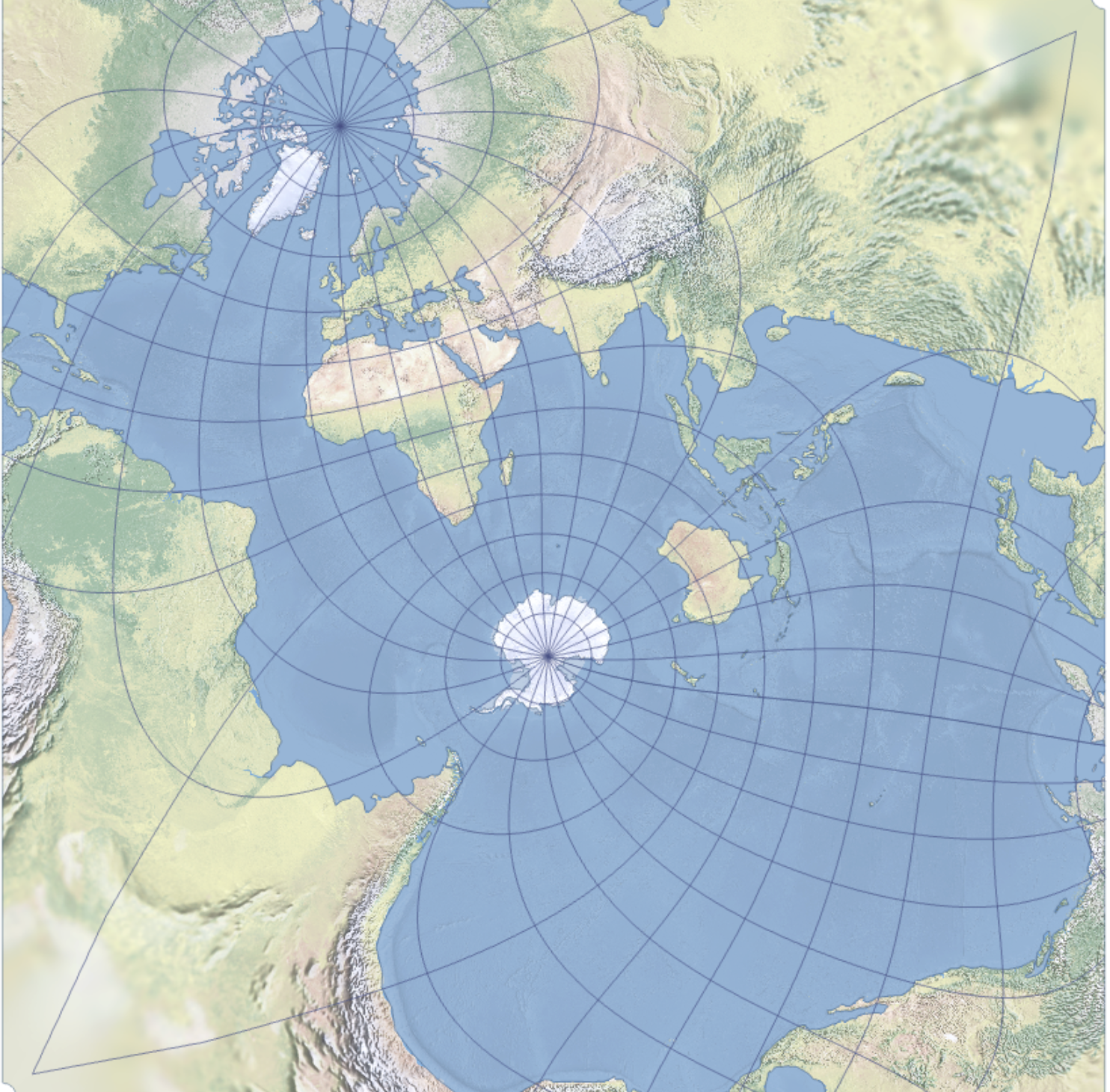
- People grow up with maps that emphasize Europe and the North Atlantic. This projection breaks that mental fixation, putting Europe and the North Atlantic in a minor corner of the map, almost an afterthought that barely catches the eye.
A slightly more recognizable version [of the Spilhaus Projection] is below.
June 5, 2026
The Lord of the Flies was just a novel
We often use The Lord of the Flies as a shorthand way to illustrate the darkness in the hearts of men, and that, absent civilizations, men descend into a hellscape of violence, hatred, and all-against-all destructive competition. Yet the real-life case of a group of boys isolated for an extended time didn’t go at all the way the novel did:

More and more I’m learning that the nihilistic claptrap we were all told was genius was just Leftist demoralization propaganda.
Situations like this have occurred, and the children didn’t turn into little monsters. In fact they survived quite well.
In June 1965, six boys named, aged 13 to 16 “borrowed” a fisherman’s boat hoping to reach Fiji or New Zealand. After a storm damaged the sail and rudder, they drifted for eight days surviving on fish and rainwater collected in coconut shells, before washing up on the rocky uninhabited island of ‘Ata.
Rather than descending into chaos during their months there the boys created a mini society. They planted vegetables, collected and stored rainwater, and maintained a permanent fire. They even built a gymnasium with homemade weights, a badminton court, and chicken pens.
They divided daily chores using rosters, resolved conflicts with time-outs instead of fighting, began and ended each day with songs and prayers. One boy, Gilligan’s Isle style, constructed a guitar from driftwood and coconut shell to boost morale. When one of the children broke his leg falling off a cliff the others set it with sticks and leaves and took over his work. They ate fish, coconuts, eggs, wild taro, bananas, and later chickens they had discovered in an ancient volcanic crater.
They endured this for for fifteen months, and never once turned into murderous thugs. A far cry from what we were told would happen.
It wasn’t just William Golding manufacturing dark stories, of course:
May 27, 2026
The Real T26 “Tanker” M1 Garand
Forgotten Weapons
Published 5 Jan 2026The name “tanker” has been applied to shortened M1 Garand rifles for a long time and today we are looking at one of the rifles that was the genesis of that concept. It actually has nothing to do with tanks; the idea for a shortened M1 came from the Pacific Warfare Board of the US Army, looking for a handier weapon for jungle fighting. During 1944 when this idea was proposed, Springfield Arsenal was already independently working on the M1E5, a very similar paratrooper version of the M1. The PWB ordered the 6th Infantry Division in the Philippines to make 150 samples for testing, of which two were sent back to Springfield for testing.
In testing, the T26 showed the same problems as the M1E5 — excessive recoil, noise, and concussion. Despite this, 15,000 were recommended for production in the summer of 1945, but the war ended before any production actually took place. The name “tanker” came later, when companies started making cut-down Garands for commercial sale and thought that marketing them as specialized tanker weapons would help them sell.
Thanks to the Springfield Armory National Historic Site for giving me access to this truly unique specimen from their reference collection to film for you! Don’t miss the chance to visit the museum there if you have a day free in Springfield, Massachusetts: https://www.nps.gov/spar/index.htm
(more…)
May 24, 2026
The PRC would need a literal “short, victorious war” to defeat the US
On Substack, Tom Kratman looks at the economic and strategic weakness of the Peoples Republic of China should it get into a serious shooting war with the United States:
China’s strategic position is appalling, and at least the higher party cadres and senior military leadership have to know that it is. Why? China is utterly dependent on both imports and exports to keep their economy going and to feed themselves. By that latter, I don’t just mean they need to import food, though they do to the tune of one third. That’s bad enough, but they also need to import fertilizer to grow the inadequate amount of food they grow for themselves. No, nitrogen and phosphates aren’t a huge problem; they are net exporters. Potash is a problem. Loss of potash imports probably cut their grain production by about ten percent. This would be painful, but survivable with a touch of rationing and some weight loss.
Except for one thing, oil and natural gas. Cut those off and grain production drops by a third within two years and probably forty percent after that. On top of the loss of the third that they must import, that’s serious hunger.
And another thing, farm machinery and transportation. China only produces about a quarter of its oil needs domestically. Cut those off and mechanization of farming must be reduced.
Add in that this kind of food reduction also means they must stop feeding food animals.
Moreover, while a good deal of their transportation net runs off of electricity, which can be produced by the coal China does have, at what we might call the strategic level, getting the food from the farms to the railheads and from the railheads to markets to kitchens requires liquid fuel. China’s ability to produce liquid fuel from coal exists, but it is tiny.
Add in the increased need for liquid fuel for their military in this case.
A long series of interrogatories to Grok suggests that China’s total food production and importation collapses by seventy percent or more within two or three years if they go to war with us.
It won’t be sudden; they probably have about a year’s worth of food in storage against such a day. But within three years? We’re talking an entire civilization in kwashiorkor1 and marasmus2.
How do they keep that industrial civilization going in the absence of food and energy imports, or the exports that have kept their economy going? They likely don’t.
Although China’s population appears to be in accelerating collapse, they still have a lot more people than we do. Surely that represents … nothing. For a war fought largely at sea it represents nothing. Yes, they can, at least for the moment, build more ships faster than we can. However, we can build things to sink ships faster than they can build ships. Thus, we’ll keep our existing naval supremacy.
There’s a worse factor in there, though; in China sons are just a lot more important than daughters. No, I don’t care if this upsets western feminist sensibilities; we are not talking about the west but about China. Daughters, assuming they marry, go on to take care of their husband’s family. Sons take care of the parents. It is the rare Chinese family with an extra son to spare.
But can’t they build enough ships to overwhelm our blockade in the short term, at least? No, they can’t. China is surrounded by enemies on land, Vietnam, India, and Russia predominant among them, though none of the neighbors – barring, maybe, North Korea – really likes China or doesn’t fear it. No, however much public kissy face they may engage in for foreign consumption, China and Russia have long-standing, intractable issues between them. China is a threat to Russia and vice versa in ways we are not.
So all the manpower and money spent on a navy is largely wasted. They’re not going to get a navy large, powerful, and competent enough to take us on and, if they really try to, we will manufacture a war – the United States is good at this – to trim them down to size before they can. Worse, every increment of money and manpower they spend on the navy is money and manpower not spent on the much more important army and air force.3
- Caused by protein deficiency.
- Caused by deficiency in all macronutrients.
- The Navy is much more important to us because we have no serious land enemies in this hemisphere.
Update, 25 May: Welcome, Instapundit readers! Have a look around at some of my other posts you may find of interest. I send out a daily summary of posts here through my Substack – https://substack.com/@nicholasrusson that you can subscribe to if you’d like to be informed of new posts in the future.
May 22, 2026
QotD: The cargo cults of New Guinea
You may remember that Guns, Germs, and Steel is framed as a reply to a man named Yali, a “remarkable local politician” whom Diamond encountered while walking on the beach in New Guinea in July of 1972. (Back before Diamond’s second career as a pop-science public intellectual, he was an ornithologist focusing on the birds of northern Melanesia.)1 They chatted for a while about the prospects for New Guinean independence, and local birds, and then Yali asked a question that Diamond spends a couple of paragraphs boiling down to something like, “Why did human development proceed at such different rates on different continents?” (Which is of course what Guns, Germs, and Steel tries to answer.) But that’s not actually the way Yali put it, and his real question — indeed, his whole story, which is fascinating in its own right — suggests a whole ‘nother set of answers
Yali should be better-known.2 He may have been from a backwards backwater, but he’s one of the true Player Characters of history. If we lived in a better world, he would be the subject of a prestige cable drama3 — or maybe a Robert Eggers film, because the values and assumptions of his society are incredibly foreign to a Western audience. And so to really understand and appreciate Yali’s story (and the question he asked an American ornithologist on the beach one day) you need some background about the tribal cultures of the New Guinea coast and their reaction to contact with Europeans. Which is to say, you need to understand cargo cults! Because what Yali actually asked (per Diamond’s recollection twenty-odd years later) was: “Why is it that you white people developed so much cargo and brought it to New Guinea, but we black people had little cargo of our own?”
“Cargo” is the catchall word for Western material culture in Pidgin English,4 the lingua franca of New Guinea’s many language isolates, and New Guineans were understandably obsessed: before European contact, they were living in the literal Stone Age. It would be an exaggeration to say that they hadn’t made any technological progress since their ancestors settled the island 50,000 years earlier, since they domesticated several local plants (taro, yams, and the cooking banana) and got pigs plus a little admixture from some passing Austronesians about 1500 BC, but they were solidly Neolithic and had been since time immemorial. So of course as soon as they encountered cargo — especially steel tools, tinned meat and dried rice, and cotton cloth — they wanted it desperately. And they almost universally believed they could get it by ritual activity.
The prescribed rituals varied. One set, recorded in secret by an American Lutheran missionary in the late 1930s, involved the locals setting up tables in front of the local cemetery and decorating them with flowers, food, and tobacco. Then they danced wildly until dawn in twitching, trembling fits so uncontrolled that some devotees continued to sway and shake for days or weeks afterward. Those lucky people were believed to have a special connection to the ancestors that would let them receive dream messages about the cargo shipments their tables and dancing would surely bring. A different cult was led by a man who had a long piece of iron he claimed brought him messages from the future. He told his followers that if they set out all their food in cemeteries as offerings to their ancestors, handed all their Western goods and money to him for safekeeping, and renamed Tuesday to Sunday, they could expect a god to send them airplanes full of cargo flown by the spirits of the dead disguised as Japanese servicemen. These spirits would bring them rifles, tanks, and other materiel and help them drive out the white people, and then the god would change the natives’ skin from black to white. Oh, and also there would be storms and earthquakes of unimaginable violence.
Forget everything you think you know about cargo cults. (Especially forget those pictures you may have seen of “decoy” airplanes or satellite dishes made out of straw and wood: one popular airplane photo is from a Japanese straw festival, another is a Soviet wind tunnel model, and the radio telescope is just one advertisement from a British ice cream company.)5 Nowadays we use “cargo cult” as a lazy shorthand for “copying what someone successful seems to be doing without really knowing why and hoping you get the same result,” but that’s not what was happening at all. If the New Guinea natives built airstrips, it wasn’t out of a belief that airstrips attract cargo planes like planting milkweed brings Monarch butterflies — that would be seem silly but basically understandable from our frame of reference. No, it’s much weirder than that. They built airstrips for exactly the same reason anyone else does: because they thought cargo planes were coming. They just thought the planes were coming because of the dancing.
This is a story about epistemology. And also about Jesus sending you a case of Spam in the mail.
Jane Psmith, “REVIEW: Road Belong Cargo, by Peter Lawrence”, Mr. and Mrs. Psmith’s Bookshelf, 2025-04-21.
- Okay, fine, it’s actually his third career — he was a specialist in cell membrane biophysics before he started publishing on birds.
- Kudos to commenter Gary Mar, who did his part in this project by alerting me to this book in the first place.
- Just in case anyone reading this has contacts in showbiz, my other idea for a cable drama is the story of Charles V, Philip II, and William of Orange. The emperor of half the known world, the son and heir raised far away, the beloved ward who betrayed him… It would win twelve Emmys.
- Which is not actually a pidgin but a creole! Nowadays it’s more often called Tok Pisin (etymologically, obviously, from “talk pidgin”). Most Tok Pisin vocabulary comes from English, but the grammar and pronunciation are very different and the orthography makes it hard to read. Still, if you try saying it out loud you can sometimes get the gist: “Wetman noken haitim samting moa” pretty easily becomes “white man no can hide’em something more”, and actually means something like “the white man will not keep anything secret from us any longer”.
- Credit for tracking down the sources of those images goes to Ken Shirriff in this blog post, which Gwern kindly sent me when I started talking about this book review.
May 18, 2026
Isoroku Yamamoto – the admiral and the postwar legend
Big Serge examines the popular memory of Japanese admiral Isoroku Yamamoto, the architect of Japan’s early naval war successes against the United States from 1941 onwards, contrasting the postwar image with the man himself:
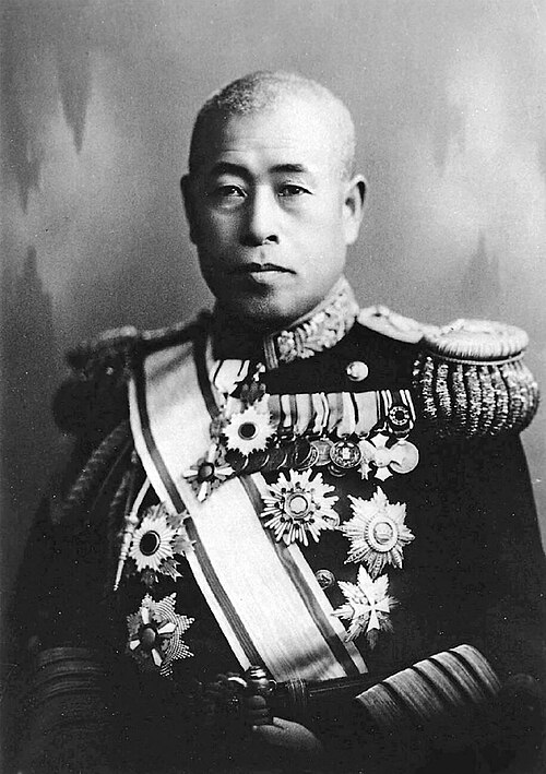
Admiral Isoroku Yamamoto, Commander-in-Chief of the Imperial Japanese Navy’s Combined Fleet.
Photo from the National Diet Library via Wikimedia Commons.
Japanese leadership in the Second World War enjoys noticeably lower name recognition than their German counterparts. Most people with a cursory knowledge of the war know the core German leadership group around Hitler — Himmler, Goering, Goebbels, Speer, and perhaps Heydrich and Bormann — and the all-star lineup of German generals like Rommel, Manstein, and Guderian. In contrast, the only particularly notorious member of Japan’s nebulous leadership group is General Hideki Tojo, who served as Prime Minister for most of the war and became the centerpiece defendant in the postwar trial. As far as Japanese commanders go, the list of name-brand personnel has but a single entry: Isoroku Yamamoto.
Yamamoto’s life and career present a fascinating trajectory that shapes a particular, sympathetic view of the man. A veteran of the Russo-Japanese War, he spent much of his 30’s in the United States, studying at Harvard and serving as naval attache in Japan’s Washington embassy. He therefore had a first hand understanding of America’s industrial depth, and was famously pessimistic about Japan’s prospects in a a war against the United States. “Anyone who has seen the auto factories in Detroit and the oil fields in Texas”, he argued, “knows that Japan lacks the power for a naval race with America”. In one of his more famous and widely recited (though often badly translated) remarks about a war with the United States, he told Prime Minister Fumimaro Konoe in September 1940:
If I was told that I had to do it, then you will certainly observe the Navy going all out for half a year to a year. However, I do not hold conviction about the outcome after 2-3 years.
This quote certainly seems remarkably prescient, in light of Japan’s initial wave of operational successes, which slowly faded away as American combat power ramped up. Far more famous still is his remark, after the attack on Pearl Harbor, that Japan had “awakened a sleeping giant, and filled him with terrible resolve”.
All of this shapes the perception of Yamamoto as a quasi-tragic figure who understood that Japan was unlikely to defeat the United States in the Pacific War, counseled against the conflict, and then dutifully tried to play a losing hand as well as he could once war had been thrust upon him against his own advice. Yamamoto was furthermore a critic of the Japanese Army’s war in China and a particularly vocal opponent of the Tripartite Pact with Germany and Japan, lending credence to the idea that he was war-averse.
This is the Yamamoto of American popular memory, and indeed of a great deal of Japanese postwar writing: a sort of samurai Cassandra, too perceptive and cosmopolitan for the militarist regime he served, a man who fired the opening shot of the Pacific War with a heavy heart and no illusions.
It is certainly true that Yamamoto had an appropriately pessimistic assessment of Japan’s prospects in an extended conflict with the United States. What is less often appreciated is that Yamamoto did not, on the basis of this assessment, conclude that Japan ought not to fight. He concluded instead that, if Japan was going to fight, it had to fight differently — with greater boldness, more risk, and an aggressive search for a decisive stroke. He did not spend the eighteen months before Pearl Harbor advocating for peace. He spent them designing what was, on balance, the single most aggressive operational scheme that was possible — and then only barely — within Japan’s kinetic parameters.
This is the critical distinction between Yamamoto-the-man and the Yamamoto of postwar hagiography. He was not a pacifist, reluctant or otherwise. He was a Japanese naval officer of strong patriotic conviction, deeply committed to his service and his nation, who happened to understand the arithmetic of industrial war better than most of his colleagues. Notwithstanding his appreciation for America’s vast industrial base, he shared a broader Japanese disdain for American martial proclivities, dismissing American naval officers as a club of “golfers and bridge players”. His understanding of the United States did not produce pacifism. It produced, rather, a particular kind of operational philosophy — one which held that Japan’s best hope in a war with the United States was to front-load its risk-taking, to achieve a string of dramatic early victories that would either compel American negotiation or, failing that, push the eventual American counter-offensive as far into the future as possible. In either case, the operational prescription was the same: bold, high-risk operations aimed at decisive results.
May 15, 2026
“One of the most iconic pictures of WWII” – the seen and the unseen, USN edition
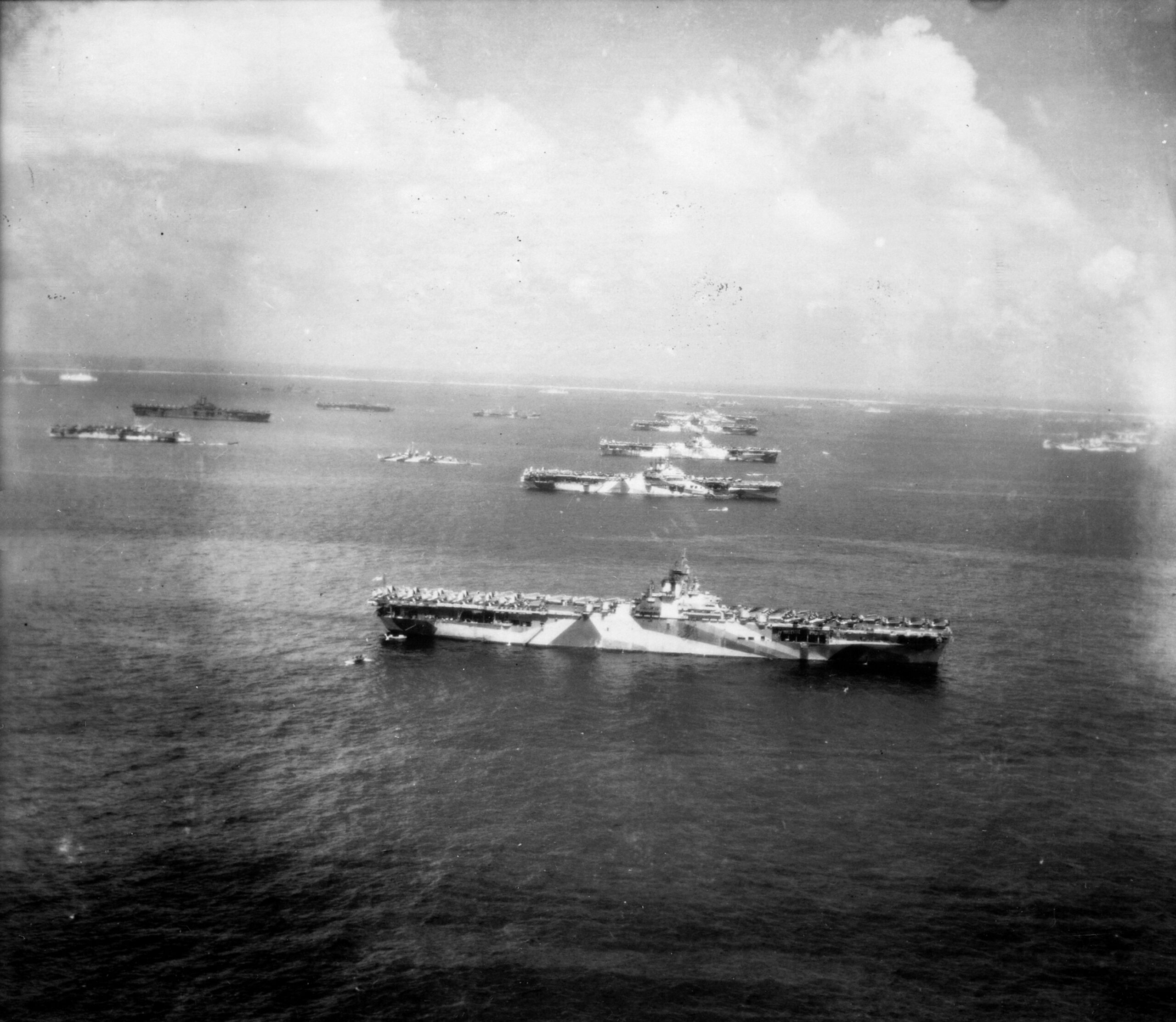
CDR Salamander posts an iconic US Navy photo from late 1944, showing the unparalleled naval might of the American efforts against Japan. But, as with Bastiat’s famous economic essay, there are the obvious things we see and the important but unseen things that matter just as much:
Murderers’ Row. Ulithi anchorage, December 8th, 1944. Just three years after the attack on Pearl Harbor.
One of the most iconic pictures of WWII.
The carriers are (from front to back): USS Wasp (CV-18), USS Yorktown (CV-10), USS Hornet (CV-12), USS Hancock (CV-19) and USS Ticonderoga (CV-14).
The oldest of those ships, Yorktown, was only 19 months old. The youngest, Hancock, was commissioned only a little under eight months earlier. All were laid down and took from a bit under three to a bit under four years to build.
Just a year prior, the US Navy was so short of aircraft carriers, it had to borrow a carrier from the Royal Navy.
At first glance, it appears to be a flex of American naval power at flood tide — the aircraft carrier’s unassailable invincibility manifest — and it is. However, when you dig deeper, it has a more important story. It gives a warning. It informs us today, if we are willing to listen.
It isn’t about the power of being the world’s greatest shipbuider, that we were. It isn’t about an unequalled ability to project national will across the Pacific like no nation ever has in human history, which it is.
No. That isn’t what it tells us that is most important.
As we have done more than once over the last two decades, we’re taking a holder of a front row seat on the Front Porch and CDR Salamander Plank Owner Sid’s comments, in this case from yesterday, and bringing it to a standalone post.
Most of this post is his. The insight certainly is.
The actual story this picture tells is much more sobering, right there in plain sight, but you can’t see it.
The reality is that on the day this picture was taken, the Fast Carrier Task Force (TF 38/58) was down an entire Task Group from where it started two months earlier.
USS Franklin (CV-13) was severely damaged on 27 OCT by kamikaze and had to return [to] CONUS for repairs.
USS Belleau Wood (CVL-24) was severely damaged in the same attack.
USS Princeton (CVL-23) was sunk on 24 OCT by a Judy dive bomber.
USS Essex (CV-9) had a devastating hit by a kamikaze on 24 NOV followed by a disabling machinery casualty requiring a trip back to CONUS for repairs.
USS Enterprise (CV-6) departed a few days earlier for repairs in Pearl Harbor.
All the carriers in this picture had been damaged to varying degrees. Damage that today would require a trip to the yard to fix, like the absent Enterprise and Essex.
For example Ticonderoga (fourth Essex in the line from the bottom) would take damage to her radar waveguides in January. That could not be repaired forward and she would have to return to Bremerton as well.
March 31, 2026
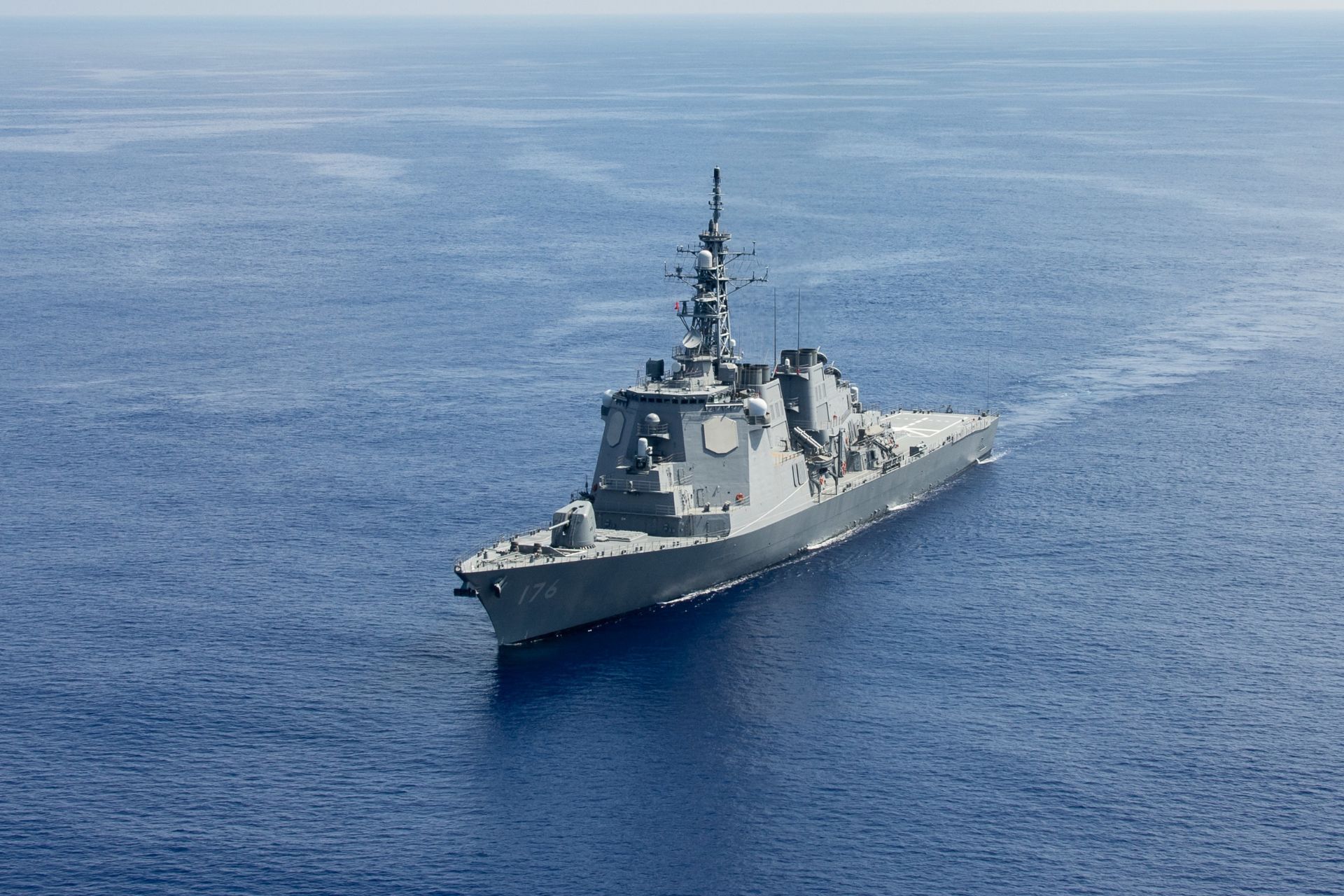
Japan’s navy … uh, I mean the “Japan Maritime Self-Defense Force”
On Substack, Francis Turner discusses what serious countries do (so you know the topic isn’t anything to do with Canada), and part of the post is about the Japanese Navy Japan Maritime Self-Defense Force and its latest ship building program:
![]()
Last month Japan started work on its second ASEV (Aegis System Equipped Vessel), which should probably classed a Guided Missile Cruiser, though it is unclear if the C designation will be used (let’s face it Japan still calls its two “not really aircraft carriers, honest guv” aircraft carrying warships “Helicopter Destroyers”. Though apparently it plans to change that soon).
At 190m long and 25m broad, the ASEVs will be some of the largest non-aircraft carrier ships being built by anyone this century1 until the Trump battleships start construction. The Trump battleships are projected to be about 50% larger but they haven’t yet been funded let alone contracted. The USN’s Zumwalts are roughly the same size.
It isn’t just the size that is impressive, it is also the speed of construction. The ASEV as a concept showed up in ~2020 when Japan decided the land based Aegis Ashore program was a failure and cancelled it. In October 2024, after about four years, plans had been made, budget allocated and contracts awarded for the two ships. Construction of the first started last July (2025) and the second last month (February 2026). Construction time is estimated to be around three years, with the first delivered/commissioned in March 2028 and the second one year later. Why one year later and not six months earlier? My guess is that the reason is to incorporate lessons learned from sea trials and operating the first in the final construction stages of the second. This seems similar to the Izumo/Kaga construction a decade ago.
Put together and you have ships that will have gone from concept to contract award in 4 years and contract award to fully-functioning delivery in under 5 years — assuming there are no delays. That seems plausible, the Izumo and Kaga were built in about the same time frame, and stands in stark contrast to the procurement speed of the US Navy and any European navy. The first Zumwalt, for example took over 5 years to go from concept to start of construction and another 5+ from there to commissioning and then another 4 to full acceptance. The ASEVs are also expected to be a lot cheaper, costing around JPY400B or about US$2.5 billion for the initial version. There will undoubtedly be upgrades — e.g. drone defenses, laser or rail guns — and there are some new features compared to previous ships — the SPY7 radar from Lockheed Martin for example — but this is an evolution of existing Japanese and US Aegis destroyers rather than a brand new concept which helps explain why I am confident about the timeline and budget.
Although the ASEV’s primary role is missile defense, there is no reason why one might not, in the fullness of time, be loaded with offensive missiles such as the TLAM or antiship missiles. Indeed the Naval News article lists both as options:
Each vessel will feature a 128-cell Vertical Launch System (VLS) — significantly more than the 96 cells installed on Japan’s latest Aegis destroyers.
The VLS will be capable of launching:
– SM-3 Block IIA interceptors, jointly developed by Japan and the United States for ballistic missile defense
– SM-6 missiles, capable of engaging advanced aerial threats, including hypersonic glide vehicles
The ships will also support Japan’s emerging counterstrike capability.
Planned armament includes:
– the extended-range Type 12 anti-ship missile (ship-launched improved variant)
– the U.S.-made Tomahawk cruise missile
Is that TLAM in your launcher or are you pleased to see me?
Notably the Tomahawk capability has already been fitted to one of the Aegis destroyers this class is supposed to replace. A 128 cell ASEV firing TLAMs could be very unpleasant for Little Rocket Man; if it fired antiship missiles that could make a Chicom invasion of Taiwan pretty miserable just on its own. It would also make a phenomenal commerce raider / blockade enforcer if such roles were needed.
[Aside: Unlike some country’s missiles I’d be pretty confident that the Type 12 anti-ship missile will work well]
As CDR Salamander observed on X, the real question is why Japan doesn’t make a few more and sell them to countries/navies that struggle with procurement. And for that matter why it doesn’t make a couple more for itself. Perhaps it will. I figure there’s a couple of years before there will be yard space to build them so there’s no hurry to make that decision.
Russia’s Kirov class battlecruisers are larger but a) they were built in the 1970s/80s and b) only one is currently active (for some definition of active).
Japan’s decision to rebuild naval strength has been noted by others, too:
February 5, 2026
On The Line with Vice-Admiral Angus Topshee, commander of the Royal Canadian Navy
The Line
Published 3 February, 2025Today on On The Line, Matt Gurney is joined by Vice-Admiral Angus Topshee, commander of the Royal Canadian Navy, for an extended, wide-ranging conversation recorded in the library of the Royal Canadian Military Institute in downtown Toronto. The discussion ranges across geopolitics, the state of the world, the state of Canada’s navy, what’s going right for the fleet, and what still needs to improve.
First, a correction from your host. During the conversation, Matt incorrectly stated at several points that Canada intends to procure 15 new submarines. Admiral Topshee was too kind to interrupt him during the recording, but the correct number is 12. That mistake was entirely Matt’s, and he regrets the error.
With that out of the way, the conversation spans the globe. Admiral Topshee discusses what’s happening in Europe with Russia and Ukraine, and in the Pacific, where growing Chinese power and influence is challenging long-held assumptions about global security. There’s also extensive discussion of the Arctic, why it matters, and what is changing there. Procurement comes up as well — shipyards, new ships for the fleet, and what it will actually cost to deliver on plans that now enjoy broad political support.
They also spend time on what Canada itself needs to sustain a much larger navy and armed forces. Do we have enough bases? Enough reservists? Are people being enrolled into the navy quickly enough? And how, realistically, could Canada expand its forces rapidly in a time of war?
It’s a long, free-ranging conversation about geopolitics, the evolution of warfare, and the future of the Royal Canadian Navy. Check it out today on On The Line. And special thanks to the Royal Canadian Military Institute for hosting this recording of the podcast. For more like this, visit ReadTheLine.ca, and as always, like and subscribe.
0:00 Intro
0:26 Vice-Admiral Angus Topshee
54:16 Outro#OnTheLine #RoyalCanadianNavy #AngusTopshee #CanadianForces #Geopolitics #ArcticSecurity #NavalPower #CanadaDefence #MattGurney
February 2, 2026
The Biggest Naval Battle in History: Leyte Gulf 1944
Real Time History
Published 5 Sept 2025In Fall 1944, Japan is set on stopping the US from re-capturing the Philippines, a vital trade route between the Japanese home islands and the resource-rich occupied territories to the south. With a complex plan they want to strike the US Navy as it’s landing on Leyte island. The resulting series of battles is today known as the Battle of Leyte Gulf, the biggest naval battle in history.
(more…)
December 12, 2025
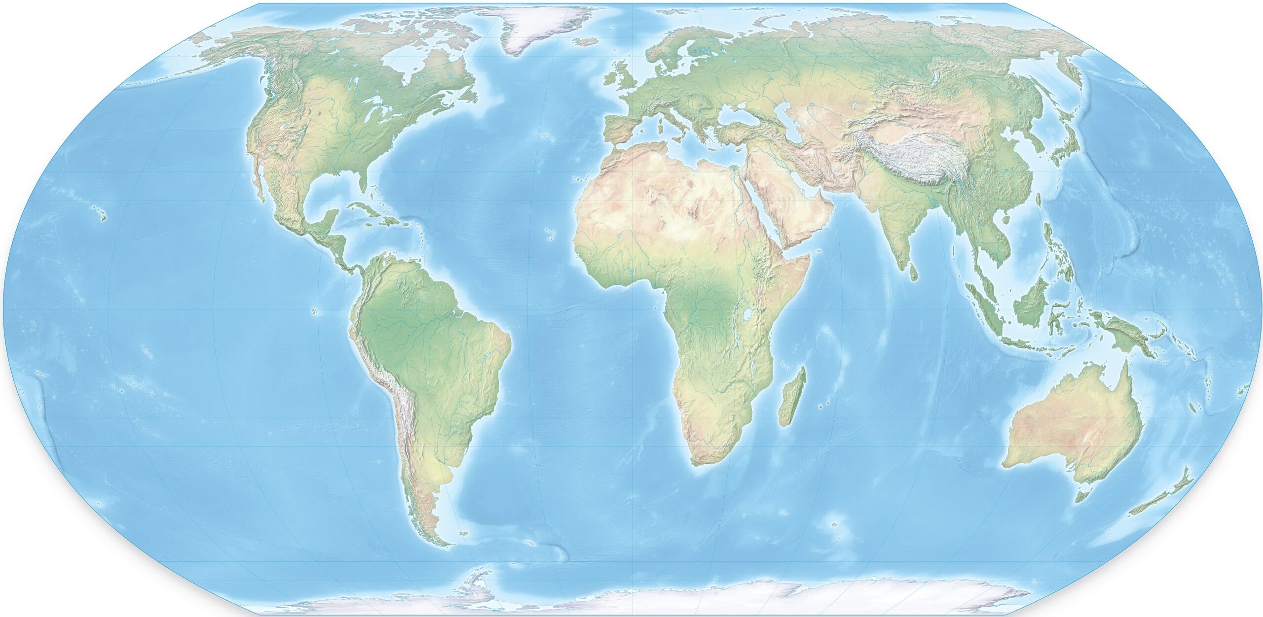
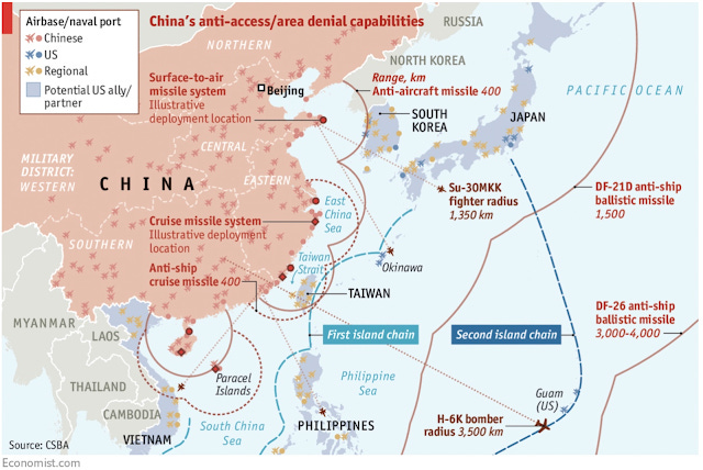
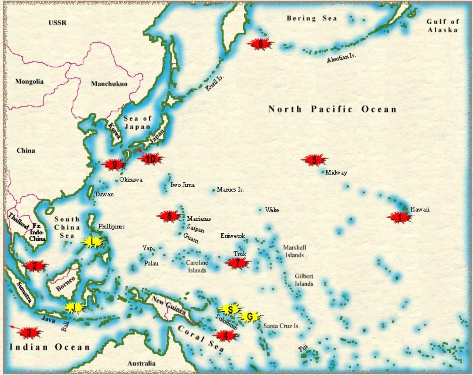
Re-orient your map to understand China’s view of the world
CDR Salamander provides a helpful guide to seeing the world, specifically their Pacific front, by turning your map sideways. I hope you won’t look back on this from a slightly later date when the maps get all flaggy and arrow-y:
I first saw this map three years ago, and it recently resurfaced in my thoughts.
I remain convinced that a lot of the problem with trying to get everyone to fully understand the challenge in the Western Pacific is that to a large part, we think in a “north-up” orientation.
I don’t think that is all that helpful.
Just a few days ago, we had another Pearl Harbor Day anniversary and we’ve all seen the maps, usually centered on Hawaii, where the Imperial Japanese Navy’s Kidō Butai comes at the Pacific Fleet from stage left off the map. Then we fought battles in the Coral Sea, Midway, and so on.
To the lay eye — or to those who don’t have time to dig into the reasons — a traditional north-up map looks disjointed; things seem all over the place.
No, not really. Let’s bring back that first map.
[Click to embiggenate]
For both Imperial Japan in the early-mid 20th century and Communist China today, the most important part of this map is the access to the resources in or going through the bottom-right hand corner.
Today’s greatest bone of contention — not unrelated to the most important part of the map mentioned above — is Taiwan, right at the mouth of the funnel.
If we need to bring a fight there, that is one hell of a fight to get there if the People’s Republic of China (PRC) wants to prepare a proper welcome for us.
For the PRC, the primary military threat to plan for comes across the Pacific into a funnel that terminates at its most important SLOC. It’s the United States of America, and the US has a series of islands leading right into the heart of the PRC’s. It starts in Hawaii — Midway, Wake, Guam — and then to U.S. allies: the Philippines, Japan, and Australia.
They’re planning a layered defensive fight. Their actions make that clear.
Make no mistake, we may say we are going to “defend Taiwan”, but to do that we will have to fight an aggressive war across the Pacific, into the enemy’s prepared funnel.
Update, 13 December: Welcome, Instapundit readers! Please do have a look around at some of my other posts you may find of interest. I send out a daily summary of posts here through my Substack – https://substack.com/@nicholasrusson that you can subscribe to if you’d like to be informed of new posts in the future.
December 8, 2025
Eating aboard a US Submarine during World War 2
Tasting History with Max Miller
Published 1 Jul 2025Slow-cooked steaks with tomatoes and onions with mashed potatoes and gravy
City/Region: United States of America
Time Period: 1945Being a crew member aboard a submarine during World War II was one of the most dangerous jobs in the US military with a fatality rate of over 20%. This, and the extremely cramped and uncomfortable quarters, were why the food aboard a US sub was really good. If nothing else, at least you had delicious food to keep you going.
These steaks cook up to be fall-apart tender and delicious, and the mashed potatoes have wonderful flavor, even if the texture is a little different from regular mashed potatoes. They kind of remind me of the mashed potatoes I’d get as a kid in school, which were also probably made from dehydrated potatoes.
SWISS BEEF STEAKS
Portion: 1 (6-ounce) steak.
100 PORTIONS
Beef, bone-in……60 pounds
OR
Beef, boneless……42 pounds
Flour……2 pounds……1/2 gallon
Salt……6 ounces……3/4 cup
Pepper……1/2 ounce……1 3/4 tablespoons
Fat……2 pounds……1 quart
Tomatoes……12 pounds, 12 ounces……2 No. 10 cans (6 1/2 quarts).
Onions, sliced……6 pounds……4 1/2 quarts
Salt……1 ounce……2 tablespoons
Flour (for gravy)……1 pound……1 quart
Water, cold……
Cut meat into 6-ounce steaks 1 to 1 1/2 inches thick.
Sift together flour, salt and pepper. Pound into steaks.
Cook steaks in fat until browned on both sides. Place in roasting pans.
Add tomatoes. Cover with onion slices. Sprinkle with 1 ounce salt.
Cover pans. Cook in slow oven (300°F.) 3 hours or until steaks are tender.
Drain liquid from Swiss steaks. Make a paste of flour and water. Stir into steak liquid. Cook until thickened. Pour over steaks. Reheat.MASHED POTATOES (Using dehydrated, shredded potatoes)
Portion: Approx. 4 1/2 ounces (approx. 2/3 cup).
100 PORTIONS
Water……5 pounds, 8 ounces……2 gallons
Potato shreds, dehydrated, precooked……5 pounds……2 gallons
Salt……3 ounces……6 tablespoons
Milk, liquid, hot……3/4 gallon
Butter, melted……1 pound……1 pint
Heat water to vigorous boil. Pour over potatoes. Cover.
Let stand in warm place 15 minutes or over low heat 10 minutes.
Add salt. Stir vigorously 15 to 20 minutes or until smooth.
Add milk and butter. Whip until light. Serve immediately.
— The Cook Book of the United States Navy by the United States Department of the Navy Bureau of Supplies and Accounts, Washington, D.C., 1945
December 6, 2025
Battle of Tarawa, 1943
Real Time History
Published 5 Dec 2025The Marine and US Army landing on the Tarawa Atoll’s Betio and Makin islands were the first operations in the new Central Pacific front of the Pacific War. Tarawa was one of the deadliest amphibious landings for the Marine Corps which hadn’t yet perfected such complex operations. But the lessons learned at Tarawa would already be applied a few months later at Kwajalein and Eniwetok.
(more…)
December 3, 2025
Battle of Peleliu 1944
Real Time History
Published 18 Jul 2025In September 1944, the US 1st Marine Division is on its way to another amphibious invasion in the Pacific – the tiny island of Peleliu. For almost half the Marines it will be their baptism of fire against veteran Japanese troops with a new defensive doctrine. Some American commanders call for the operation to be cancelled, but it goes ahead. By its end, half the Marines and all the Japanese will be killed or wounded – but was Peleliu worth it?
(more…)