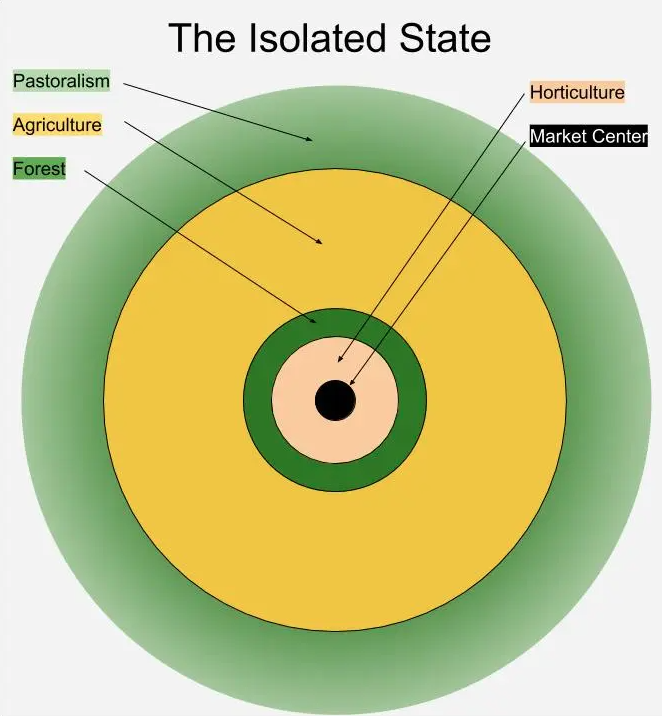
Diagram of von Thünen’s model from The Isolated State, after Morley (1996), 62. The agriculture ring is subdivided by intensity (intensive, long-lay and three-field), but here I have merged them for simplicity. The agriculture zone is wider because it did, in fact, tend to cover a larger area. The fade in the pastoralism zone is meant to indicate shifts from ranching to transhumance.
Once out of the innermost zone of very high intensity usage, we reach the middle zones of von Thünen’s model, which are devoted primarily to agriculture, falling in degrees of intensity as we move away from the city. This is where you should expect to see rolling seas of wheat and barley, as well as large scale cultivation of things like olives and grapes, as the climate permits. This seems to be what, for instance, Tolkien has in mind when he describes the Pelennor as fair and fertile townlands running down to the Anduin.
(I should note this this zone is subdivided into three groups: intensive agriculture, long-lay agriculture and three-field agriculture. We might discuss those terms further if future posts bring us to discussing how pre-modern farms work, but for now, I don’t want to get too – pardon the pun – deep in the weeds.)
Now, I noted before that for small cities, the horticultural zone might be entirely contained inside the city walls. The reverse is true as well – the larger the city, the further out these zones can get pushed – and this is especially true of the middle zone. As it extends, it tends to create miniature population centers within it (villages) – usually along roads (we’ll get to them).
But for very large cities, the area of grain cultivation can be truly massive. As I’ve noted in an earlier post, a city of around 500,000 would need to pull cereal production from an area of arable land close to the size of the state of Massachusetts. Rome – at nearly a million – imported grain from up and down the entire Italian coast, North Africa and even Egypt. A middle zone that large could contain not merely villages, but other towns and even large cities, whose own land-use patterns would be substantially distorted by the “pull” of the mega-city at the center. […] as a rule of thumb, if the cereal cultivation zone extends more than 20 miles out from the center, you should expect to see smaller market towns within it (because people want a market within a day’s walk).
What does this kind of zone look like? That actually depends a lot on terrain – expect villages surrounded by fields on areas of good, arable land. In a fairly wet environment (like Northern Europe), those villages might radiate out from the city. In arid environments like Egypt or Mesopotamia, the farmland (and thus the peasant population) is densely concentrated along the rivers, because water availability becomes a strong determinant of arability.
One thing Americans specifically tend to get a bit off here is that the farms are not likely to be evenly spaced over the terrain. We are very used to the agricultural landscape created by things like the Homestead Acts (1862-1930), which offered very large chunks of land (often as many as 640 acres) for purchase, creating a lot of very spaced out farms. Peasant agriculture in the pre-modern period doesn’t tend to organize like this.
Instead, peasant agriculture tends to cluster in villages, with fields radiating out from the villages (which in turn, often have their own micro-garden zone and local forests for wood). Part of the reason for this is that farmland within the village is typically not held as big, standalone farmsteads. Instead, it is either held communally, or else each family owns several small plots spread over different ecological zones (the better to be protected from the risk of a year being wet or dry or cold or whatever – if you have a little land everywhere, then probably something will grow somewhere every year. I’ll talk more about subsistence survival strategies in a future post).
In some societies, these peasant villages may also be mixed in with large elite-held (often slave worked) estates, but there’s an important caveat here. The grand estates – like Roman villas and latifundia – generally do not completely displace the local peasantry (in part because they rely on that peasantry to supply surplus labor). The role of the “big man” and these sorts of large market-oriented estates is complex and worth its own post. But in terms of land-use patterns, such estates generally exist within a landscape of smaller farmers, not in a vast sea of other large estates.
The outermost zone in the model is dedicated to pastoralism (“ranching” technically, but I’d like to be a bit more broad). Pastoralism can take the form of enclosed ranching, but can also be mobile in various ways. I won’t describe ranching too much – this human terrain is still much in evidence and well documented. But mobile forms of pastoralism are more foreign, I suspect, to most of my readers. Transhumance – the moving of livestock between seasonal summer and winter pastures (often up the mountain in summer and down the mountain in winter, for instance – this is “vertical” transhumance) is a common form of limited pastoral mobility.
Transhumant pastoralists do tend to have permanent homes at one end of the route (typically the lower winter pastures for vertical transhumance). These may cluster in villages and are likely to plug into the infrastructure network spreading out from the city. I bring this up mostly because this is how you do get the “rolling hills of empty grassland” terrain so common in depictions of fantasy cities: these areas aren’t empty at all, but merely transhumant pastures not currently in use.
(Side note: This fact about pastoralism is especially worth noting: pastures which are regrowing in the “off” season often might look empty and unused to an outsider, but trespassing on such grounds can bring lethal retaliation. Because these pastures are not unused, but in fact engaged in the vital task of regrowing to support the herd in the following season. This is also the case for true nomads as well, by the by. The reason, of course, is that if those pastures are not grown when the herds are migrated back, the pastoralist’s entire pattern of subsistence is disrupted, endangering his survival. This is a not infrequent cause of friction between pastoralists and agricultural peoples who neighbor each other).
Pastoralism exists on the outer edge of the model for two reasons. First, it is very low density. While the goods it produces (wool, milk, meat) are important, it produces them at a very low density. Agriculture can support massively greater population densities than pastoralism, so high population density tends to push the pastoralists out. There’s a political/military dimension to this as well: the concerns of the farmers tend to dominate political thinking in the city (where, you will recall, the political and military elite are), and the farmer’s greater population density tends to allow them to “push” the pastoralists further from the city and onto marginal lands – either economically (buy the land) or militarily (fight the pastoralists and shove them off).
Second, pastoralism has very low transportation costs. This is because the goods produced by pastoralists can, by and large, walk themselves to market. This is called transporting them “on the hoof”, a phrase my students continue to find funny and are surprised to learn is a real term. Major cattle and animal markets are often still located within city centers, but a shepherd can simply walk his animals to market for sale. That greatly reduces transportation costs, which also tends to push pastoralism out to the edges of the economic network.
Bret Devereaux, “Collections: The Lonely City, Part I: The Ideal City”, A Collection of Unmitigated Pedantry, 2019-07-12.
October 27, 2026
QotD: The outer “zones” surrounding a typical pre-modern city
No Comments »
No comments yet.
RSS feed for comments on this post. TrackBack URL