Published on 1 Jul 2015
Meet the Thighmaster of urban public policy: Streetcars.
Municipal politicians all across the country have convinced themselves that this costly, clunky hardware can revitalize their flabby downtown economies.
That includes the fearless leaders of America’s capital city. The DC government has spent hundreds of millions of dollars over the last decade trying to erect a streetcar line in the up-and-coming neighborhood of H Street. The project has been an epic disaster, perfectly demonstrating how ill-suited streetcars are to modern urban life.
Watch the full video above, or click below for downloadable versions. And subscribe to Reason TV’s YouTube channel for daily content like this.
July 4, 2015
Reason.tv – The Secret Scam of Streetcars
Comments Off on Reason.tv – The Secret Scam of Streetcars
July 2, 2015
Frankford Junction, Pennsylvania
Rob McGonigal looks at the history of the railways in the area of Frankford Junction, where Amtrak train 188 came to grief in May:
In the aftermath of the tragic May 12 derailment due to excessive speed of Amtrak train 188 in Philadelphia, many casual observers wondered what a 50-mph curve is doing in the middle of the fastest, busiest rail corridor in the nation. It’s a reasonable question, especially given the generally tangent track and flat topography in the area.
The existence of that curve traces back to the earliest years of railroads in Philadelphia. As in many cities, Philadelphia’s rail network developed in piecemeal, uncoordinated fashion. What became Amtrak 188’s route through the city began in the 1830s as three separate projects.
The Philadelphia, Wilmington & Baltimore ran generally southwestward from a terminal about a mile south of downtown (“center city” to Philadelphians). The Philadelphia & Columbia, part of the Main Line of Public Works rail/canal system to Pittsburgh, utilized a terminal in center city. The Philadelphia & Trenton, which connected with services to New York, originated in Kensington — an inconvenient 2½ miles northeast of center city. As Albert Churella relates in the first volume of his mammoth history of the PRR (University of Pennsylvania Press, 2013), municipal authorities in 1840 granted the P&T permission to extend its line into center city, where it would connect with other railroads. However, fierce opposition from teamsters, who profited from hauling freight between the rail terminals, and area residents, who did not want steam trains in their streets, prompted the city to revoke permission, and the P&T was not extended.
Two decades later, it was clear that the three lines should be connected. In 1864 the Junction Railroad was opened, linking the PW&B with the P&C’s successor on the line to the west — the Pennsylvania Railroad. (Indeed, the PRR had interests in all three of the lines by this time.) Three years later the Connecting Railway opened. It diverged from the P&C/PRR line at a place designated Mantua Junction (and later, in expanded form, Zoo interlocking), arced around the northern part of the city, and connected with the P&T in the Frankford section of Philadelphia. As with the connection at Mantua Junction, the geometry of the lines at Frankford Junction resulted in a sharp curve.

Comments Off on Frankford Junction, Pennsylvania
July 1, 2015
Budd Railcars in 1952 – “Clear Iron”
Uploaded on 17 Aug 2011
Educational film released in 1952 by Marathon Newsreel Production in association with the Budd company. Shows the railcars being manufactured and in operation. Also features many steam and diesel trains from the early 1950’s.From https://en.wikipedia.org/wiki/Budd_Rail_Diesel_Car
The Budd Rail Diesel Car or RDC is a self-propelled diesel-hydraulic multiple unit railcar. In the period 1949-62, 398 RDCs were built by the Budd Company of Philadelphia, Pennsylvania, United States. The cars were primarily adopted for passenger service in rural areas with low traffic density or in short-haul commuter service, and were less expensive to operate in this context than a traditional locomotive-drawn train. The cars could be used singly or several coupled together in train sets and controlled from the cab of the front unit. The RDC was one of the few versions of the DMU-type train diesel multiple unit to achieve commercial success in North America.
The basic car was adapted from a standard 85 ft (25.91 m) coach. They were powered by two Detroit Diesel (then a division of General Motors) Series 110 diesel engines, each of which drives an axle through a hydraulic torque converter, a technology adapted from military tanks of World War II. RDC trains were an early example of self-contained diesel multiple units, an arrangement now in common use by railways all over the world.
[…]
Both the Canadian National Railway (CN) and Canadian Pacific Railway (CP) purchased RDCs. The Canadian National purchased 25 cars outright, and acquired many more second-hand from the Boston and Maine Railroad. These cars, which the CN called Railiners, were used primarily on secondary passenger routes. The CP purchased 53 cars. The first one ran on November 9, 1954, between Detroit, Michigan and Toronto. It was the first stainless steel passenger train to operate in Canada. CP used the RDCs, which it called Dayliners, throughout its system. CP also made extensive use of them on commuter trains around Montreal and Toronto. Via Rail inherited many of these cars when it took over CN and CP passenger services in 1978.[39] Via continues to use RDCs on the Sudbury–White River train in Ontario.
Another Canadian purchaser of RDCs was the Pacific Great Eastern Railway, which operated passenger service between North Vancouver and Prince George. RDCs continued to operate on this route until all passenger service ended under BC Rail, PGE’s successor, in 2002.
Extensively refurbished RDCs were supposed to been used to operate Blue22, a rail service between Toronto Union Station and Pearson Airport, by 2010. The service, which was transferred to Metrolinx ownership and opened in 2015 as the Union Pearson Express, ultimately uses newly designed Nippon Sharyo DMU trains instead.
Comments Off on Budd Railcars in 1952 – “Clear Iron”
Riding the “Budd cars” from Sudbury to White River
Malcolm Kenton reports on his recent trip on VIA Rail’s unique passenger service between Sudbury and White River, Ontario:
VIA Rail Canada’s Sudbury-White River train (formerly known as the Lake Superior), consisting of two (sometimes three) Budd-built Rail Diesel Cars (RDCs) that operate three days a week in each direction along a 301-mile section of Canadian Pacific’s transcontinental main line, is the only passenger train of its kind in North America for several reasons. It is currently the only regularly scheduled intercity passenger service using Budd RDCs (the only others being used as backups on two commuter lines, Tri-Met’s Westside Express in Oregon and Trinity Railway Express in Texas, and on a handful of excursion trains). It is the only intercity passenger train in Canada that uses Canadian Pacific trackage for a significant stretch (western Canada’s privately-run Rocky Mountaineer excepted). And it is one of three passenger train routes in northern Ontario that delivers people, supplies and equipment to points along the line that are not accessible by road (except for a few dirt logging roads) or air (except for a few wilderness lodge sites that have small landing strips for bush planes). I had the opportunity to travel aboard this service — whose parallel cannot be found on this side of the 49th Parallel — last week (June 18 & 19).
VIA refurbished all three of the RDCs within the past year, giving them new seats, electric outlets at each seat, restrooms, heating & air conditioning systems, and wheelchair accessibility features. One car has a large restroom whose doors slide open or closed and lock with the push of a button. A crew member on my trip referred to it as “the Cadillac bathroom.” Next to the engineer’s cab on each coach is an area that doubles as a baggage area and a crew break area, with refrigerator, sink and coffee maker. The highest passenger train speed limit on the route is 75 mph, reached for just a brief stretch between Sudbury and Cartier. Otherwise, it generally tops out at 60 — though on rare occasions where the train has had to run with just one RDC, it is limited to 45 mph — meaning the trip is usually completed just barely within the engineers’ legal limit of 12 consecutive hours of service, between which periods crews must be given at least eight consecutive hours of rest.
The vast majority of passengers on “the Budd cars” (as most locals refer to the train) — usually only a handful on each trip, though occasionally all 48 seats on both cars are occupied for a portion of the trip — are visiting remote cabins along the line to fish, hunt/trap, canoe or kayak, mountain bike, or otherwise enjoy the great outdoors. There are also year-round residents of the mid-route communities of Ramsey and Chapleau who use the train to visit family and friends and go to medical appointments in Sudbury (as there are no medical specialists in their hometowns). Passengers bring aboard an array of gear for wilderness expeditions — canoes, fishing gear, coolers, etc. — which is loaded into the baggage section of one of the RDCs (in the busy season, a third RDC car is added that is solely a baggage car, as was the case on my jaunt). And owners of cabins and retreats near the line use the train as a parcel service, having others buy groceries and supplies at one of the endpoints and drive them to the train, to be loaded into the baggage hold and unloaded at the stop nearest their outpost.
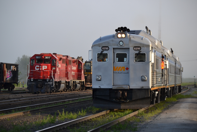
Eastbound train 186, with the RDC baggage car in the lead, passes a CP freight train carrying backhoes at the small White River, ON yard on June 19, approaching the station to begin its run towards Sudbury. (Photo by Malcolm Kenton)
Comments Off on Riding the “Budd cars” from Sudbury to White River
June 29, 2015
More on the “self-driving truck” issue
In the comments to this post, Tom Kelley provided a worthwhile digression on the topic that I felt deserved a wider audience, so with his permission, here’s Tom’s response:
Given that the trucking industry has been my sandbox for quite some time, I can safely extend Megan’s prognosis to also include the low long-term risk of job losses due to self-driving vehicles.
Frankly, I have to be wary of any “expert” who can’t even get the name of his source (the American Trucking Associations — yes, plural — not the American Trucker Association) transcribed correctly.
Apart from the myriad technical issues standing in the way of driverless trucks, the insurmountable barrier is anti-competitive trucking regulations passed on behalf of the government’s favorite white elephant, the rail industry. Invariably, these regulations are tarted up under some guise of safety (Let’s see, was it a truck or a train that blew the town of Lac-Mégantic off the map??? Hmm).
The bottom line is that any change that would have the slightest possibility of making trucking more productive is quickly met with massive dis-information campaigns, and even more massive lobbying from the rail industry. Even the most minor dimensional changes designed to reflect the current realities of truck freight transportation stand little if any chance of making it past regulators with a permanent disdain for free enterprise.
We can’t have electronically actuated brakes on trucks because the regulators have no grasp of brakes or electronics, and somebody wants to replace the driver with electronics? Seriously? Of course these same folks seen to have no problem flying cross-country at 500 MPH in a commercial jetliner that is literally flown by wire.
And even if the government types were perfect actors in this little tale, then you have the American tort law system, run/regulated by, for, and about the trial lawyers. Even with professional truck drivers who can deftly avoid putting incompetent car drivers on their way to a Darwin award, hundreds of four-wheeler drivers still manage to commit suicide-by-truck every year, followed quickly by their otherwise destitute estates suing innocent trucking companies for millions.
Can’t you just hear the jury summation now: “The eeevvilll trucking company wanted to save a few pennies by outsourcing the driver’s job to a microchip! The must be punished! My client, a fourth cousin of the homeless man who jumped off a bridge in front of a truck MUST be awarded $10 million for the pain and suffering from losing a relative he never met. No justice, no peace!”
No insurance company in their right mind would insure a driverless truck for real-world operation.
There’s no question that the technology is available to make the concept work, I was on-board numerous autonomous vehicles of all sizes back in 1997.
It will take several major societal shifts before any serious degree of autonomy makes it into real world trucking operations.
Comments Off on More on the “self-driving truck” issue
June 25, 2015
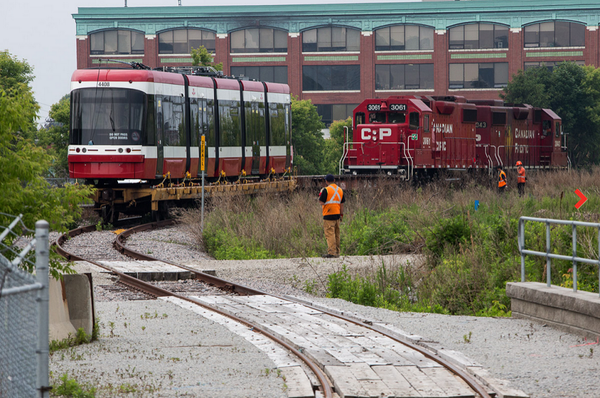
Delivering a new streetcar to the TTC
On Facebook, James Bow linked to this photoset from Toronto Life, showing the stages a new streetcar goes through when the railway delivers it to the TTC:
Click to see full-sized image at Toronto Life
Comments Off on Delivering a new streetcar to the TTC
June 16, 2015
Light rail is usually not the solution you need for better public transit
At Coyote Blog, a look at the new Phoenix light rail system’s miraculous ability to stall the growth in public transit usage:
As I have written before, Phoenix has seen its total transit ridership flat to down since it built its light rail line. This after years of 6-10% a year increases in ridership. Most cities, even the oft-worshipped Portland, has seen the same thing. Here is the chart for Phoenix (if you look closely, you can see how they fudged the bar scaling to make light rail ridership increases look better).
The reason is that per passenger, or per mile, or per route, or whatever way you want to look at it, rail systems are 1-2 orders of magnitude more expensive than buses. Since most cities are reluctant to increase their spending on transit 10-100x when they build trains (and to be fair, proponents of rail projects frequently make this worse by fibbing about future costs and revenue expectations), what happens is that bus routes are cut to fund rail lines. But since buses are so much cheaper, 10 units of bus capacity, or more, must be cut for each one unit of rail capacity.
[…]
By the way, beyond the obvious harm to taxpayers, the other people hurt by this are the poor who are disproportionately bus users. Rail systems almost always go from middle/upper class suburbs to business districts and seldom mirror the transit patterns of the poor. Middle class folks who wouldn’t be caught dead on a bus love the trains, but these same folks already have transportation alternatives. The bus lines that get cut to fund the trains almost always serve much lower income folks with fewer alternatives.

This comment from slocum may show the hidden intent in many cities’ drive to replace bus routes with light rail services:
BTW, am I the only one who suspects that there might be a little method to the madness of building light rail and cutting back on bus service? Isn’t it a pretty effective way to drive gentrification by making cities more attractive to the well-off and less so to the poor?
Come for the shiny new light rail system. Stay for the snobbery and active shunning of the poor!
Comments Off on Light rail is usually not the solution you need for better public transit
May 24, 2015
QotD: Impressions of Dresden
We reached Dresden on the Wednesday evening, and stayed there over the Sunday.
Taking one consideration with another, Dresden, perhaps, is the most attractive town in Germany; but it is a place to be lived in for a while rather than visited. Its museums and galleries, its palaces and gardens, its beautiful and historically rich environment, provide pleasure for a winter, but bewilder for a week. It has not the gaiety of Paris or Vienna, which quickly palls; its charms are more solidly German, and more lasting. It is the Mecca of the musician. For five shillings, in Dresden, you can purchase a stall at the opera house, together, unfortunately, with a strong disinclination ever again to take the trouble of sitting out a performance in any English, French, or, American opera house.
The chief scandal of Dresden still centres round August the Strong, “the Man of Sin,” as Carlyle always called him, who is popularly reputed to have cursed Europe with over a thousand children. Castles where he imprisoned this discarded mistress or that — one of them, who persisted in her claim to a better title, for forty years, it is said, poor lady! The narrow rooms where she ate her heart out and died are still shown. Chateaux, shameful for this deed of infamy or that, lie scattered round the neighbourhood like bones about a battlefield; and most of your guide’s stories are such as the “young person” educated in Germany had best not hear. His life-sized portrait hangs in the fine Zwinger, which he built as an arena for his wild beast fights when the people grew tired of them in the market-place; a beetle-browed, frankly animal man, but with the culture and taste that so often wait upon animalism. Modern Dresden undoubtedly owes much to him.
But what the stranger in Dresden stares at most is, perhaps, its electric trams. These huge vehicles flash through the streets at from ten to twenty miles an hour, taking curves and corners after the manner of an Irish car driver. Everybody travels by them, excepting only officers in uniform, who must not. Ladies in evening dress, going to ball or opera, porters with their baskets, sit side by side. They are all-important in the streets, and everything and everybody makes haste to get out of their way. If you do not get out of their way, and you still happen to be alive when picked up, then on your recovery you are fined for having been in their way. This teaches you to be wary of them.
Jerome K. Jerome, Three Men on the Bummel, 1914.
Comments Off on QotD: Impressions of Dresden
May 23, 2015
Debunking the “GM killed the streetcars” conspiracy theory
There are many railfans who still believe, strongly and passionately, that General Motors was involved in a devious plot to kill off the streetcars across North America in order to sell more buses. At Vox.com, Joseph Stromberg explains that this wasn’t the case — in fact, the killer of the streetcar/interurban/radial railway systems was their willingness to lock in to long-term uneconomic agreements with local governments in exchange for monopoly privileges:
Back in the 1920s, most American city-dwellers took public transportation to work every day.
There were 17,000 miles of streetcar lines across the country, running through virtually every major American city. That included cities we don’t think of as hubs for mass transit today: Atlanta, Raleigh, and Los Angeles.
Nowadays, by contrast, just 5 percent or so of workers commute via public transit, and they’re disproportionately clustered in a handful of dense cities like New York, Boston, and Chicago. Just a handful of cities still have extensive streetcar systems — and several others are now spending millions trying to build new, smaller ones.
So whatever happened to all those streetcars?
“There’s this widespread conspiracy theory that the streetcars were bought up by a company National City Lines, which was effectively controlled by GM, so that they could be torn up and converted into bus lines,” says Peter Norton, a historian at the University of Virginia and author of Fighting Traffic: The Dawn of the Motor Age in the American City.
But that’s not actually the full story, he says. “By the time National City Lines was buying up these streetcar companies, they were already in bankruptcy.”
Surprisingly, though, streetcars didn’t solely go bankrupt because people chose cars over rail. The real reasons for the streetcar’s demise are much less nefarious than a GM-driven conspiracy — they include gridlock and city rules that kept fares artificially low — but they’re fascinating in their own right, and if you’re a transit fan, they’re even more frustrating.
This is one of the reasons I’m generally against new plans to re-introduce streetcars (or their modern incarnations generally grouped under the term “light rail”), because they fail to address one of the key reasons that the old street railway/interurban/radial systems died: they were sharing road space with private vehicles. Light rail can provide a useful urban transportation option if they have their own right-of-way, but not if they are merely adding to the gridlock of already overcrowded city streets.
And once again, I’m not anti-rail … I founded a railway historical society and I commute most work days on a heavy rail commuter network. I don’t hold this position due to some anti-rail animus. If anything, I regret the passing of railway systems more than most people do, but I recognize that they have to be self-supporting (or close to self-supporting) to have a chance to survive. Being both more expensive and less convenient than alternative transportation options is a sure-fire path to extinction.
Comments Off on Debunking the “GM killed the streetcars” conspiracy theory
May 22, 2015
Al Stewart – “Trains”
Published on 19 Mar 2013
In the sapling years of the post-war world in an English market town
I do believe we travelled in schoolboy blue, the cap upon the crown
Books on knee; our faces pressed against the dusty railway carriage panes
As all our lives went rolling on the clicking wheels of trainsThe school years passed like eternity and at last were left behind
And it seemed the city was calling me to see what I might find
Almost grown, I stood before horizons made of dreams
I think I stole a kiss or two, while rolling on the clicking wheels of trainsTrains…
All our lives were a whistle stop affair; no ties or chains
Throwing words like fireworks in the air, not much remains
A photograph in your memory, through the colored lens of time
All our lives were just a smudge of smoke against the skyThe silver rails spread far and wide through the nineteenth century
Some straight and true, some serpentine, from the cities to the sea
And out of sight of those who rode in style, there worked the military mind
On through the night to plot and chart the twisting paths of trainsOn the day they buried Jean Jaures, World War One broke free
Like an angry river overflowing its banks impatiently
While mile on mile the soldiers filled the railway stations’ arteries and veins
I see them now go laughing on the clicking wheels of trainsTrains…
Rolling off to the front across the narrow Russian gauge
Weeks turn into months and the enthusiasm wanes
Sacrifices in seas of mud, and still you don’t know why
All their lives are just a puff of smoke against the skyThen came surrender; then came the peace
Then revolution out of the east
Then came the crash; then came the tears
Then came the thirties, the nightmare years
Then came the same thing over again
Mad as the moon, that watches over the plain
Oh, driven insaneBut oh, what kind of trains are these, that I never saw before
Snatching up the refugees from the ghettoes of the war
To stand confused, with all their worldly goods, beneath the watching guards’ disdain
As young and old go rolling on the clicking wheels of trainsAnd the driver only does this job with vodka in his coat
And he turns around and he makes a sign with his hand across his throat
For days on end, through sun and snow, the destination still remains the same
For those who ride with death above the clicking wheels of trainsTrains…
What became of the innocence they had in childhood games
Painted red or blue, when I was young they all had names
Who’ll remember the ones who only rode in them to die
All their lives are just a smudge of smoke against the skyNow forty years have come and gone and I’m far away from there
And I ride the Amtrak from New York City to Philadelphia
And there’s a man to bring you food and drink
And sometimes passengers exchange a smile or two rolling on the humming wheels
But I can’t tell you if it’s them or if it’s only me
But I believe when they look outside they don’t see what I see
Over there, beyond the trees, it seems that I can just make out the stained
Fields of Poland calling out to all the passing trainsTrains…
I suppose that there’s nothing in this life remains the same
Everything is governed by the losses and the gains
Still sometimes I get caught up in the past, I can’t say why
All our lives are just a smudge of smoke, or just a breath of wind against the sky
Comments Off on Al Stewart – “Trains”
The trains of war – the military application of steam power
James Simpson on the revolution in military affairs triggered by the development of the steam engine and the railways:

Navvies working on the Grand Crimean Central Railway, 1854. Charles Walker: Thomas Brassey, Railway Builder, 1969. (via Wikipedia)
Trains were cutting-edge weapons of war in the 19th century — and all the major powers were figuring out how to deploy them. The Europeans learned how to move troops by train. The Americans — how to fight on rail cars. The British, meanwhile, found they could dominate an empire from the tracks.
In today’s world of tanks, bombers and submarines, it’s perhaps hard to believe that the train was once an amazingly mobile weapons platform. They might be locked to their rails, but for over a century trains were the fastest means of hauling troops and artillery to front lines across the world.
The invention of the railway shaped warfare for a century. Rails allowed force projection across immense distances — and at speeds which were impossible on foot or by horse.
[…]
The first demonstration of the military efficacy of the railroads was the 1846 Polish Uprising. Prussia rushed 12,000 troops of the Sixth Army Corps, with guns and horses, to the Free City of Krakow to help put down the Polish rebellion. In this period of nationalist uprisings, Russia and Austria also used their railroads against similar uprisings from 1848 to 1850.
A lack of infrastructure and experience stifled the success of these early endeavors. Due to a lack of rolling stock, suitable platforms and double-track stretches, the trains sometimes operated far slower than a man could march on foot.
Austria was first to get it right. In 1851, the Austrian Empire shuttled 145,000 men, nearly 2,000 horses, 48 artillery pieces and 464 vehicles over 187 miles.
Comments Off on The trains of war – the military application of steam power
May 14, 2015
Solving the Amtrak problem requires thinking outside the box … really outside
At The Federalist, Sean Davis explains why throwing more taxpayer money at Amtrak isn’t going to do much good:
“Amtrak doesn’t get enough government money,” is the kind of thing someone says when that person doesn’t understand anything about Amtrak, or government, or money.
Created by Congress in 1970, Amtrak was meant to replace the private rail companies that, according to Amtrak, “had operated services at a net loss of millions of dollars for many years.” Net losses of millions of dollars, you say? According to its unaudited financial statements, Amtrak lost over a billion dollars in 2014, the last year for which annual revenue and expense data are available.
Amtrak lost nearly $1.3 billion in 2013. Since its creation, Amtrak has racked up over $31 billion in accumulated losses. And every penny of those losses has been covered by federal taxpayers.
Amtrak has a lot of problems. A lack of taxpayer generosity is not one of them, not even close. The key to fixing Amtrak, to making it function as a “for-profit corporation,” which is how the Federal Railroad Administration, Amtrak’s overseer, officially describes the passenger rail organization, is not increasing the volume of federal cash it sucks up every year. The solution is not to reform this and that to make the government-owned company work better or more efficiently. And selling off its assets to the highest bidder won’t fix Amtrak, either.
No, the key to fixing Amtrak is to just give it away. Hand over the entire enterprise to whichever rail company wants it. “But that’s crazy!” you might say. “Giving it away for free makes no cents!”
Comments Off on Solving the Amtrak problem requires thinking outside the box … really outside
May 13, 2015
Why are railroads dragging their feet over more efficient braking systems?
Fred Frailey discusses the U.S. Department of Transportation mandate that all crude oil trains longer than 69 cars must be equipped with electronic brakes by 2021 or they will restrict the speed of oil trains to 30 MPH at all times. The current standard braking system for railroads in North America is pneumatic, which have worked well for decades, but have inherent problems as modern trains have gotten longer and heavier. One of the biggest problems is that pneumatic brakes have a relatively long activation time — when the engineer operates the brake in the lead locomotive, it takes quite some time for that to propagate all the way through the train. This creates situations which can cause derailments as the lead cars begin to slow down, while the rest of the train is still travelling at full speed.
The preferred replacements are called electronically controlled pneumatic brakes (ECP), where instead of the brakes operating by pressure changes in the air line, the brakes would be controlled by a separate electronic circuit that would allow simultaneous brake application in all cars in the train.
It seems electronic braking has no friends in the railroad industry. I find this puzzling. Research I’ve read suggests there is both a safety and business case to be made. One explanation for the bum’s rush being given ECP comes from someone whose career was immersed in railroad technology: “The mechanical departments say the ECP brakes don’t save enough on wheels and brake shoes to justify implementation. The track departments say that ECP brakes don’t reduce rail wear enough to justify implementation. Transportation departments say that ECP brakes don’t save enough fuel to justify implementation. And improved train running times, improved train dynamics, and improved engineer performance are all soft-dollar savings which don’t count. No one ever bothers to sum up total benefits.” Silos, in other words.
So I’ll make the case for ECP. (By the way, the standards were developed two decades ago by the same AAR that now vigorously opposes their implementation.) A train equipped with electronic braking is hard-wired, allowing instant communication from airbrake handle in the locomotive to every brake valve on the cars. The principal advantages are that all brakes instantly apply and release at the same time, the air supply is continually charged, engineers can gradually release and reapply brakes, and undesired emergency braking (dynamiters, they’re called) virtually disappear. In-train forces, such as slack roll-in and roll-out, are greatly reduced, and that lessens the risk of derailment. Moreover, stopping distance is reduced 40 to 60 percent, permitting higher train speeds and higher speeds approaching restricting signals. Longer trains are possible. Longer trains run at higher speeds increase the capacity of the railroad network. Because air is always charging, braking power is inexhaustible; plus, a train can stop and instantly restart. Brakes, draft gear, wheels, and bearings require less maintenance. Existing federal regulations would allow train inspections every 5,000 miles instead of the present 1,500 or 1,000 miles.
Those are a lot of advantages. In a report commissioned by the Federal Railroad Administration in 2005, the consulting company Booz Allen Hamilton estimated the cost of full implementation of ECP at $6 billion and the measurable savings (not including added network capacity) at $650 million a year. Booz recommended that ECP conversion begin with coal trains loaded in Wyoming’s Powder River Basin, then to other types of unit trains (presumably including intermodal trains), and finally the rest of the car fleet — all in a 15-year time frame. “As applied to western coal service,” its report stated, “the business case is substantial,” with a recovery of all costs within three years.
[…]
Several things are going on here. Silos are one. Nobody is looking at the big picture, just his or her little piece of it. The boys in the Mechanical Silo could care less about increased network capacity. The occupants of the Finance Silo don’t want to divert cash flow away from share buybacks, their favorite toy. Most of those in the CEO Silo didn’t come up on the operating side and are probably bored by the subject. In a conservative, mature business like railroading, risk taking and even forward thinking are not rewarded. And the cost of hard-wiring the car fleet would primarily be borne by shippers, who own most of the equipment, whereas railroads would reap the benefits. How to share the benefits with car-owning shippers leads to very difficult negotiations.
Comments Off on Why are railroads dragging their feet over more efficient braking systems?
April 28, 2015
Professor: New UK railway signalling system is hackable … while he’s also selling anti-hacking gear
At The Register, John Leyden offers a bit of doubt that Professor David Stupples can really be said to be an impartial observer:
The rollout of a next generation train signalling system across the UK could leave the network at greater risk of hack attacks, a university professor has claimed.
Prof David Stupples warns that plans to replace the existing (aging) signalling system with the new European Rail Traffic Management System (ERTMS) could open up the network to potential attacks, particularly from disgruntled employees or other rogue insiders.
ERTMS will manage how fast trains travel, so a hack attack might potentially cause trains to move too quickly. UK tests of the European Rail Traffic Management System have already begun ahead of the expected rollout.
By the 2020s the system will be in full control of trains on mainline routes. Other countries have already successfully rolled out the system and there are no reports, at least, of any meaningful cyber-attack to date.
Nonetheless, Prof Stupples is concerned that hacks against the system could cause “major disruption” or even a “nasty accident”.
ERTMS is designed to make networks safer by safeguarding against driver mistakes, a significant factor historically in rail accidents. Yet these benefits are offset by the risk of hackers manipulating control systems, Prof Stupples, of City University London, warned.
Comments Off on Professor: New UK railway signalling system is hackable … while he’s also selling anti-hacking gear
April 26, 2015
Debunking the myths about the destruction of NYC’s Penn Station
I admit up front that I’m a fan of railway architecture, so I readily followed along with the narrative that the wanton destruction of Penn Station in New York City was merely the most recent vandalic excess of the urban rejuvenation movement. Jim Epstein suggests that I was wrong:
In all the hoopla surrounding the 50th anniversary of New York’s Landmarks Preservation Act — Mayor Robert F. Wagner signed the legislation exactly a half century ago today — you’ll see plenty of photos of the old Penn Station taken around the time of its 1910 opening. These images depict the grand, light-filled main hall modeled after the Baths of Caracalla and the spectacular iron-and-glass train shed in its pristine state. Another series of photos shows the station being taken apart in the 1960s. In this set of images, the station looks like an ancient Roman palace; it’s as if the cranes pulling it apart are destroying the very bedrock of Western civilization.
“Seven-year-olds gasp…[when] we show them the old Penn Station,” Tara Kelly, the executive director of Friends of the Upper East Side Historic Districts, told the New York Times at an event last week celebrating the law’s half-centennial.
Penn Station’s destruction in the mid-1960s was a call to arms for the landmarks movement, leading directly to the passage of the 1965 law. Preservationists trot out these photos capable of leaving second graders breathless to remind us of why we need a government-appointed commission to save our historic buildings from cold market logic.
But this narrative is as one-sided as those photos. Profit-driven developers left to their own devices value wonderful old buildings as much as the general public they serve, but the old Penn Station was a deeply flawed structure. It emphasized form over function, so it was never a particularly good train station. And New Yorkers didn’t care for it very much — when it was still around, at least. It’s easy to revere the dead.
Comments Off on Debunking the myths about the destruction of NYC’s Penn Station