Quotulatiousness

March 23, 2024

Bhutan

Filed under: Asia, Britain, Government, History, India — Tags: , , , , , , — Nicholas @ 03:00

Ned Donovan recounts his recent trip to Bhutan, situated in the Himalaya mountains between India and China:

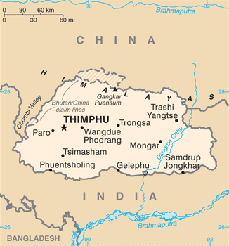
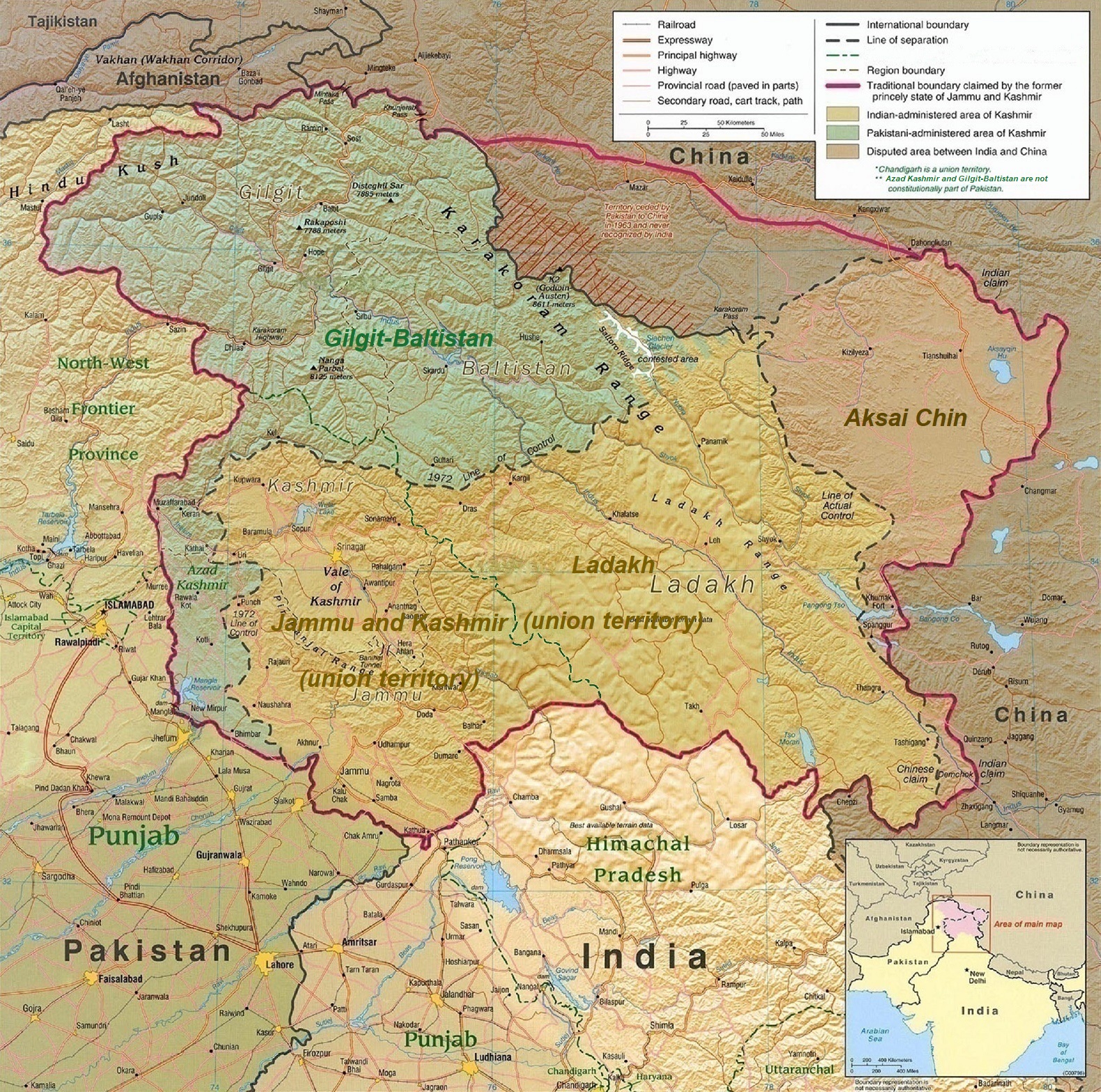
Bhutan map from the CIA World Factbook, 2010. Chinese-disputed border areas are marked with dashed lines and darker shading.
Wikimedia Commons.

Bhutan has long been a place I had wanted to visit, but it isn’t as simple as booking a ticket.

It would be remiss not to quickly situate Bhutan and its history for those unaware. It is a small kingdom east of Nepal and nestled between India and China. It has a population of around 750,000, almost all of whom are devout Buddhists. It was once a land of feuding Tibetan chieftans who were united in the 1630s by a remarkable warrior and Buddhist lama called Ngawang Namgyal. Namgyal died in 1651, but his death was kept a secret from the country for more than 50 years, with officials simply saying that the king was “on an extended retreat” and continued to keep Bhutan together by issuing decrees in his name.

While Namgyal was seen as the spiritual leader, he also established a temporal monarchy which in a slightly modified form still exists today under the leadership of the Wangchuk dynasty. The King of Bhutan’s title is the Druk Gyalpo, which literally translates to Dragon King. Over time Bhutan, being small but strategically located, faded in and out of the spheres of influence of the day from the Mughals to the British Raj. It would have been subsumed into the latter like other princely states, but in the 19th Century a British civil servant placed some files relating to Bhutan into a folder marked “External” instead of “Internal”, a small decision that ensured it remains an independent country today, albeit one “guided” on matters of defence and foreign affairs by a treaty with India.

The country only opened its borders to foreigners in 1974, to mark the coronation of the Fourth King, Jigme Singye Wangchuck. His Majesty saw the opportunity to take advantage of his accession to showcase Bhutan and its unique culture and traditions to the world, but was also aware that unrestricted tourism would put those at risk. Over time, this developed into a vision known as “High Quality, Low Volume” tourism. All visitors must have a guide and driver and also pay a daily fee — currently $100. In 1974, 287 foreigners visited Bhutan, and in 2019 more than 70,000 fee paying tourists came.

As a result of this policy, the trips are largely cultural. You take hikes in unimaginable scenery, watch local festivals where masked creatures tell villagers morality tales, and sit with locals to eat dishes made up mostly of chilis. For fun people relax with the national sport of archery, singing deliciously rude songs to put off their friends while they take shots. Tourists get to have a go but the target is brought closer and you get to use the same kind of bow young children do. Civil servants go to work in traditional dress and robe-clad monks pepper society. In the five days I spent there, much was spent talking to our compulsory guide who was a lovely man named Yarab, who had once been on the Bhutan national football team. One story Yarab told me was that of Bhutan’s transition to democracy.

The previously mentioned Fourth King oversaw Bhutan’s transition into the modern world – but with a catch. Bhutan’s development could not come at the cost of its people’s happiness. Thousands of kilometres of roads were built, free at point of use clinics quickly filled the country, and electricity and telephone hookups turned King Jigme Singye’s isolated kingdom where almost no one had access to healthcare or education into a remarkably healthy and literate little state in the space of just a few decades. Much of the money to make this possible came from selling hydroelectricity generated by dams that are powered by Himalayan glaciers. The Fourth King explained that: “water is to us what oil is to the Arabs”.

February 14, 2023

China’s awkward actions on the world stage do not charm the neighbours

Filed under: Asia, China, India, Military, Pacific — Tags: , , , , — Nicholas @ 03:00

CDR Salamander explains why the BRIC (Brazil-Russia-India-China) “coalition” is as unlikely to occur in the real world as any other opium pipe-dream:

Yes, the USA and Canada had our Balloons of February, but in the last year or so, what has China been doing to seem like a pleasant alternative to the United States to the rest of the world?

Her largest neighbor? They get sticks:

    The root cause is an ill-defined, 3,440km (2,100-mile)-long disputed border.

    Rivers, lakes and snowcaps along the frontier mean the line can shift, bringing soldiers face to face at many points, sparking a confrontation.

    The two nations are also competing to build infrastructure along the border, which is also known as the Line of Actual Control. India’s construction of a new road to a high-altitude air base is seen as one of the main triggers for a deadly 2020 clash with Chinese troops.

    How bad is the situation?

    Despite military-level talks, tensions continue. In December 2022 troops clashed for the first time in more than a year.

    It happened near the Tawang sector of Arunachal Pradesh state, the eastern tip of India. Some soldiers suffered minor injuries.

    De-escalation work has taken place since a major clash in June 2020. The Galwan Valley battle — fought with sticks and clubs, not guns — was the first fatal confrontation between the two sides since 1975.

    At least 20 Indian and four Chinese soldiers died.

    Another face-off in January 2021 left troops on both sides injured. It took place near India’s Sikkim state, between Bhutan and Nepal.

The “I” and “C” in the B.R.I.C. are not going to be close friends, ever — one of the reasons I roll my eyes at those who propose the BRIC nations as some kind of power block — something only slightly sillier than the Cold War “Non Aligned Movement.”

With the “B” being the basket case Brazil (always the nation of the future, and always will be), and the “R” being Russia, I mean, child please.

Another nation that if the PRC was just slightly more subtle and less arrogant they might have a chance to make things more difficult for the USA-Japan-Australia defense concerns is The Philippines. They had a window in the last couple of decades, but … if they’re doing this;

The PRC Wolf Warrior Lack of Charm Campaign perhaps may play well internally — and that may be all they care about — but there was a window not long ago that the PRC was playing smart on the world stage — making significant impact in Australia and having the USA happy to let them set up Confucius Institutes at our major universities, etc … but the last decade or so they somehow decided to play a different game.

July 28, 2020

How Matt Ridley stopped being an “Enviro-Pessimist”

Filed under: Economics, Environment, India — Tags: , , , , , , — Nicholas @ 05:00

It was human ingenuity that did it for him:

Spiti Valley in the Great Himalayan National Park. (The little blue speck in the middle of the photo is a truck, for scale.)
Photo by Sudhanshu Gupta via Wikimedia Commons.

If you had asked me in 1980 to predict what would happen to that bird and its forest ecosystem, I would have been very pessimistic. I could see the effect on the forests of growing human populations, with their guns and flocks of sheep. More generally, I was marinated in gloom by almost everything I read about the environment. The human population explosion was unstoppable; billions were going to die of famine; malaria and other diseases were going to increase; oil, gas, and metals would soon run out, forcing us to return to burning wood; most forests would then be felled; deserts were expanding; half of all species were heading for extinction; the great whales would soon be gone from the oil-stained oceans; sprawling cities and modern farms were going to swallow up the last wild places; and pollution of the air, rivers, sea, and earth was beginning to threaten a planetary ecological breakdown. I don’t remember reading anything remotely optimistic about the future of the planet.

Today, the valleys we worked in are part of the Great Himalayan National Park, a protected area that gained prestigious World Heritage status in 2014. The logo of the park is an image of the western tragopan, a bird you can now go on a trekking holiday specifically to watch. It has not gone extinct, and although it is still rare and hard to spot, the latest population estimate is considerably higher than anybody expected back then. The area remains mostly a wilderness accessible largely on foot, and the forests and alpine meadows have partly recovered from too much grazing, hunting, and logging. Ecotourism is flourishing.

This is just one small example of things going right in the environment. Let me give some bigger ones. Far from starving, the seven billion people who now inhabit the planet are far better fed than the four billion of 1980. Famine has pretty much gone extinct in recent decades. In the 1960s, about two million people died of famine; in the decade that just ended, tens of thousands died — and those were in countries run by callous tyrants. Paul Ehrlich, the ecologist and best-selling author who declared in 1968 that “[t]he battle to feed all of humanity is over” and forecast that “hundreds of millions of people will starve to death” — and was given a genius award for it — proved to be very badly wrong.

Remarkably, this feeding of seven billion people has happened without taking much new land under the plow and the cow. Instead, in many places farmland has reverted to wilderness. In 2009, Jesse Ausubel of Rockefeller University calculated that thanks to more farmers getting access to better fertilizers, pesticides, and biotechnology, the area of land needed to produce a given quantity of food — averaged for all crops — was 65 percent less than in 1961. As a result, an area the size of India will be freed up by mid-century. That is an enormous boost for wildlife. National parks and other protected areas have expanded steadily as well.

Nor have these agricultural improvements on the whole brought new problems of pollution in their wake. Quite the reverse. The replacement of pesticides like DDT with much less harmful ones that do not persist in the environment and accumulate up the food chain, in addition to advances in biotechnology, has allowed wildlife to begin to recover. In the part of northern England where I live, otters have returned to the rivers, and hawks, kites, ospreys, and falcons to the skies, largely thanks to the elimination of organochlorine pesticides. Where genetically modified crops are grown — not in the European Union — there has been a 37 percent reduction in the use of insecticides, as shown by a recent study done at Gottingen University.

One of the extraordinary features of the past 40 years has been the reappearance of wildlife that was once seemingly headed for extinction. Bald eagles have bounced back so spectacularly that they have been taken off the endangered list. Deer and beavers have spread into the suburbs of cities, followed by coyotes, bears, and even wolves. The wolf has now recolonized much of Germany, France, and even parts of the heavily populated Netherlands. Estuaries have been cleaned up so that fish and birds have recolonized rivers like the Thames.

June 23, 2020

Pushback for Chinese aggression in the Himalayas

Filed under: China, India, Military — Tags: , , , , , , — Nicholas @ 03:00

In Quillette, Cleo Paskal outlines the Chinese military action last week and a few of the reactions in civil society:

The western portion of the Line of Actual Control, separating the Eastern Ladakh and Aksai Chin (map by CIA). In the Demchok sector, only two claim lines are shown. The line was the focus of a brief war in 1962.
Wikimedia Commons.

High in the Himalayan mountains, Chinese soldiers ambushed Indian troops this week, resulting in a brutal battle on the Indian side of their shared border. Twenty Indians were killed, while China won’t disclose its losses. It was the deadliest confrontation on the border in over 40 years. As a result, some Indian strategists are openly discussing recognizing Taiwan and providing more visibility to the Dalai Lama, state-owned telecoms are blocking Chinese equipment from 4G upgrades, and millions of Indians downloaded an app that helps remove Chinese apps from their phones (before Google removed it). All of this comes at a time when much of the world remains angry at China’s leaders for their initial handling of the COVID-19 crisis.

This week’s apparent provocation is part of a larger recent pattern with China. From the South China Sea, to Taiwan, to Hong Kong, Beijing has been seeking to change facts on the ground in a way that benefits its own strategic and economic interests. In a recent Atlantic Council discussion of the India-China border issue (convened before the latest fighting), senior American diplomat Ambassador Alice Wells summed the situation up well: “There’s a method here to Chinese operations. [A]nd it is that constant aggression, the constant attempt to shift the norms, to shift what is the status quo, that has to be resisted.”

For decades China has tried to expand its strategic reach along its de facto south-western border through the invasion of Tibet, land swaps with Pakistan, and war with India. To this end, China treats British Empire-era maps as political props to variously brandish or dismiss, as best suits Beijing’s goals. For example, it effectively accepted the 1914-era McMahon Line delineation in its border agreement with Myanmar, but rejects it with India.

The Line of Actual Control (LAC) separating China and India runs through rugged, high-altitude terrain that has witnessed multiple conflicts going back to the 1962 India-China border war. In recent weeks, there have been Chinese incursions at several points along the LAC, reportedly involving thousands of troops. In some spots, the Chinese military is digging in on the Indian side, while expanding its already considerable support infrastructure on their side of the LAC.

Delhi is particularly concerned about Chinese advances near India’s Daulat Beg Oldie (DBO) high-altitude military airfield, an essential Indian forward base that provides oversight of the strategic Karakoram Highway (KH) linking China’s western Xinjiang Autonomous Region with Pakistan, including the Gwadar Port on the Indian Ocean. It is a key component of the multi-billion-dollar China-Pakistan Economic Corridor.

April 5, 2020

China’s geostrategic box

ESR looks at the concerns that China may be considering starting a war with the United States in the wake of the Wuhan Coronavirus:

To understand how limited the PRC’s war options are, we can start with a grasp on how difficult and unsatisfying any war of conquest would be due to the geographic box China is in. The obstacles around it are formidable.

To the south, the Himalayan massif makes all of South Asia other than a narrow coastal plain on the Southeast Asian peninsula inaccessible to serious troop movements. There are no roads or rail links. The last time the Chinese tried pushing in that direction, in 1979, they were unable to sustain an offensive at any distance from their railheads and withdrew after less than a month. Their war aim – forcing the North Vietnamese to withdraw its troops from Cambodia – failed.

To the west, the vastness and comparatively undeveloped state of China’s western hinterland is a serious logistical problem before one even gets to the border. At the borders, the Tien Shan and Pamir ranges present a barrier almost as formidable as the Himalayas. External road and rail links are poor and would be easily interdicted.

To the north, movement would be easier. It might be just within logistical possibility for the PLA to march into Siberia. The problem with this idea is that once you’ve conquered Siberia, what you have is … Siberia. Most of it, except for a small area in the south coastal region of Primorsky Kraye, is so cold that cities aren’t viable without food imports from outside the region. Set this against the risks of invading a nuclear-armed Russia and you don’t have a winning proposition.

To the east is the South China Sea. The brute fact constraining the PRC’s ambitions in that direction is that mass movement of troops by sea is risky and difficult. I recently did the math on Chinese sealift craft and despite an expensive buildup since the 1980s they don’t have the capacity to move even a single division-sized formation over ocean. Ain’t nobody going to take Taiwan with one division, they’ve has too much time to prepare and fortify over the last 60 years.

The PRC leadership is evil and ruthless, but it’s also cautious and historically literate and can read maps. Accordingly, the People’s Liberation Army is designed not to take territory but to hold the territory the PRC already has. Its mission is not conquest but the suppression of regional warlordism inside China itself. The capability for the PLA to wage serious expeditionary warfare doesn’t exist, and can’t be built in the near-term future.

It’s often said that the danger of aggressive war by China is a function of the huge excess of young men produced by covert sexual selection and the one-child policy. But to expend those young men usefully you need to get them to where they can fight and are motivated by some prospect of seizing the wives unavailable for them at home. The PRC can’t do that.

The military threat from China is, therefore, a function of what it can do with its navy, its airpower, and its missiles. And what it can do with those against the U.S. is upper-bounded by the fact that the U.S. has nuclear weapons and would be certain to respond to a PRC nuclear or EMP attack on the U.S. mainland by smashing Chinese cities into radioactive rubble.

Within the constraints of conventional warfare waged by navy and air force it is difficult to imagine an achievable set of PRC war aims that gains more than it costs.

It’s possible — even likely — that the Chinese military has something like the oft-rumoured “ship-killer missiles” that might be able to cripple or sink an American carrier … if it was in range. That makes the South China Sea, the East China Sea, and the west coast of Japan a possible no-go area for US Navy carrier strike groups. A good defensive weapon system to have on hand in case relations with the outside world go “hot”, but not a strategic game-changer. Nobody would be likely to consider anything as dangerous as a seaborne invasion of mainland China, even without the threat of wonder weapons like the ship-killer. And good defensive weapons won’t secure the trade routes that China depends on outside coastal waters.

In a lot of ways your strategic situation is like a scaled-up version of Japan’s in 1941 – you could seize the initiative with a Pearl-Harbor-like initial shock, but you can’t wage a long war because without sealane control you’ll run out of key feedstocks and even food rather rapidly. And unlike the Japanese in 1941, you don’t have the kind of serious blue-water navy that you’d need for sealane control outside the First Island Chain – not with just two carriers you don’t.

There is one way an aggressive naval war could work out in your favor anyway. You can count on the U.S.’s media establishment to be pulling for the U.S. to lose any war it’s in, especially against a Communist or Socialist country. If your war goals are limited to ending U.S. naval power projection in the Western Pacific, playing for a rapid morale collapse orchestrated by agents of influence in the U.S. is not completely unrealistic.

It’s playing with fire, though. One problem is that before you launch your attack you don’t know that your sucker punch will actually work. Another is that, as the Japanese found out after Pearl Harbor, the American public may react to tragic losses with Jacksonian fury. If that happens, you’re seriously screwed. The war will end with your unconditional surrender, and not sooner.

Update: Bone-headed typo in the headline fixed. It’s funny how you can’t see ’em until just after you click the Save button…

April 13, 2018

India and the “Quad”

Filed under: Australia, China, India, Japan, Military, Pacific, USA — Tags: , , , , , — Nicholas @ 05:00

At Strategy Page, Austin Bay discusses India’s position, both geographically and militarily with respect to China:

As the Cold War faded, a cool aloofness continued to guide India’s defense and foreign policies. Indian military forces would occasionally exercise with Singaporean and Australian units — they’d been British colonies, too. Indian ultra-nationalists still rail about British colonialism, but the Aussies had fought shoulder to shoulder with Indians in North Africa, Italy, the Pacific and Southeast Asia, and suffered mistreatment by London toffs. Business deals with America and Japan? Sign the contracts. However, in defense agreements, New Delhi distanced itself from Washington and Tokyo.

The Nixon Administration’s decision to support Pakistan in the 1971 Indo-Pakistani War [Wikipedia link] embittered India. Other issues hampered the U.S.-India relationship. Indian left-wing parties insisted their country was a “Third World leader” and America was hegemonic, et cetera.

However, in the last 12 to 15 years, India’s assessments of its security threats have changed demonstrably, and China’s expanding power and demonstrated willingness to use that power to acquire influence and territory are by far the biggest factors affecting India’s shift.

In 2007, The Quad (Quadrilateral Security Dialogue), at the behest of Japan, held its first informal meeting. The Quad’s membership roll sends a diplomatic message: Japan, Australia, America and India. Japan pointed out all four nations regarded China as disruptive actor in the Indo-Pacific; they had common interests. Delhi downplayed the meeting, attempting to avoid the appearance of actively “countering China.”

No more. The Quad nations now conduct naval exercises and sometimes include a quint, Singapore.

The 2016 Hague Arbitration Court decision provided the clearest indication of Chinese strategic belligerence. In 2012, Beijing claimed 85 percent of the South China Sea’s 3.5 million square kilometers. The Philippines went to court. The Hague tribunal, relying on the UN Convention on the Law of the Sea treaty, supported the Filipino position that China had seized sea features and islets and stolen resources. Beijing ignored the verdict and still refuses to explain how its claims meet UNCLOS [Wikipedia link] requirements.

That is the maritime action. India and China also have mountain issues. In 1962, as the Cuban Missile Crisis diverted world attention, the two Asian giants fought the Indo-Chinese War [Wikipedia link] in the Himalayas. China won. The defeat still riles India.

August 7, 2015

Looking back at April’s 7.8 earthquake in Nepal

Filed under: Asia, Science, Technology — Tags: , , — Nicholas @ 04:00

At Ars Technica, Scott K. Johnson what has been learned about the devastating earthquake that struck Nepal earlier this year:

The mighty Himalayas have been driven up into the sky by the collision of Eurasia and India, which has migrated north like a tectonic rocket over the last 100 million years. The Indian plate is being crammed beneath the crumpled Himalayan rocks along a dangerous fault that ramps downward to the north.

Lots of GPS sensors and seismometers have been deployed in the area to help seismologists study earthquakes here. Combined with precise satellite measurements of surface elevation changes, researchers have the means to work out where the movement on the fault must have occurred.

The earthquake began about 80 kilometers northwest of Kathmandu and about 15 kilometers beneath the surface. Geologists like to talk about faults “unzipping,” which is a helpful way to visualize what’s going on. A small patch of the fault plane slips, and then expands outward along the fault. In this case, the patch unzipped about 140 kilometers to the east in under a minute, traveling horizontally along the fault plane. Within that patch, the rocks slipped as much as six meters past each other.

Although it’s the seismic energy released by that sudden motion that causes the damage, the surface changes are still eye-catching — some of the GPS stations ended up two meters south of where they had been before the earthquake.

As for that seismic shaking, the pattern of building damage in Kathmandu was partly the result of the geology beneath the city. It sits on a roughly 500-meter-thick stack of lake and river sediment filling a bedrock bowl. The reverberation of seismic waves in that bowl produced a resonance, building stronger waves with a period of 4 to 5 seconds. While fewer homes were actually damaged than expected, taller buildings — which can sway at about that same frequency — didn’t fare as well. (A similar thing happened in the 1985 Mexico City earthquake, when buildings between 6 and 15 stories bore the brunt.)

May 11, 2015

Nepal’s tragic unpreparedness for disaster

Filed under: Asia, Government — Tags: , , , , , — Nicholas @ 04:00

In The Walrus, Manjushree Thapa explains why Nepal was so badly prepared for the earthquake:

Following the April 25 earthquake, Nepalis have had to learn the value of preparedness in the most painful way possible. In the aftermath, Pushpa Acharya, a Nepali friend at the University of Toronto, observed, “Knowledge was not our problem.” Indeed. We all knew that our country sits on an active fault line, where the subcontinent collided with the Eurasian plate with such force it created the Himalayas. The last big quake took place in 1934. Others have since struck, but none with the force of 1934’s 8.0 or April 25’s 7.9. We knew that a big earthquake was due.

It was our duty to prepare, and though some of us did so individually, as a society we ignored the warnings. In the past ten days, during search and rescue, and then the beginnings of relief, we’ve had to do some hard thinking about how our country could become more responsible going forward. The root problem may seem obvious: Nepal is one of the poorest countries in the world. Its poverty is, however, a symptom of our history of ill governance, and the reason for our national failure to prepare, which has kept us from becoming a functioning democracy.

When the earthquake struck, the country was in a deep and deeply depressing stupor. The governing parties — a coalition of the Nepali Congress Party and the Unified Marxist Leninists — had reached an impasse with Nepal’s thirty-three opposition parties about what kind of constitution to draft. There was no plan for the country as a whole, let alone in the case of an emergency. The drafting of a constitution has preoccupied, confounded, and eluded Nepal’s polity since 2006, when the Maoists ended a ten-year insurgency to join forces with other parties to remove Gyanendra Bir Bikram Shah. Nepal’s king had used the war as an excuse to end a fragile fifteen-year spell of democracy and install his own military-backed rule. A mass movement restored democracy, and the subsequent peace process promised to restructure the country along just and equitable lines through the drafting of a new constitution

October 20, 2012

The Himalayan fault line of 1962

Filed under: China, History, India, Military — Tags: , , , , — Nicholas @ 00:02

In a brief but bloody altercation high up in the Himalayan mountains, Chinese forces attacked and defeated Indian troops along part of the extensive border between the two nations. In History Today, Gyanesh Kudaisya looks back at the events of 50 years ago:

China and India share the longest disputed frontier in the world, extending over 4,000 km, with a contentious Line of Actual Control across the Himalayas. Fifty years ago, on October 19th, 1962, border skirmishes between China and India escalated into a full-scale war across the mountainous border. Hostilities continued for over a month, during which China wrestled 23,200 sq kms of territory from India and inflicted heavy casualties. The Indian government acknowledged the loss of over 7,000 personnel, with 1,383 dead, 1,696 missing in action and 3,968 captured by the enemy. The Chinese also conceded ‘very heavy’ losses. Then, quite suddenly, on November 21st, China announced a unilateral ceasefire and a return to border posts held by its army prior to the conflict, while retaining some 4,023 sq km of territory in the Ladakh region.

This brief war has come to define relations between Asia’s two largest countries and the border issue remains unresolved. Beijing still claims over 92,000 sq km of territory, mainly in the northeastern Indian state of Arunachal Pradesh.

The war was a dramatic turning point for India. Most Indians saw it as a ‘stab in the back’, a grave act of betrayal by the Chinese leadership, whom Jawaharlal Nehru, India’s first prime minister (1947-64), had lauded as brothers in the heyday of a friendly relationship in the mid-1950s. This was reflected in Panchsheel, ‘Five Principles of Peaceful Coexistence’, upon which in 1954 China and India inked a bilateral treaty, and the 1955 Bandung conference, where Nehru had personally introduced Chinese premier Zhou Enlai to Afro-Asian delegates in order to minimise China’s isolation.

January 24, 2010

The only surprise about this is that they’re admitting it

Filed under: Environment, Politics — Tags: , , , , — Nicholas @ 15:41

Glacier scientist: I knew data hadn’t been verified:

The scientist behind the bogus claim in a Nobel Prize-winning UN report that Himalayan glaciers will have melted by 2035 last night admitted it was included purely to put political pressure on world leaders.

Dr Murari Lal also said he was well aware the statement, in the 2007 report by the Intergovernmental Panel on Climate Change (IPCC), did not rest on peer-reviewed scientific research.

In an interview with The Mail on Sunday, Dr Lal, the co-ordinating lead author of the report’s chapter on Asia, said: ‘It related to several countries in this region and their water sources. We thought that if we can highlight it, it will impact policy-makers and politicians and encourage them to take some concrete action.

‘It had importance for the region, so we thought we should put it in.’

It was unverified, but so important that they couldn’t hold back? It would be funny, if trillions of dollars were not being forcibly redirected in useless, futile “green” directions, and the lives of billions of people may be negatively impacted by government and UN mandates on unproven technologies to curb global warming.

October 5, 2009

Tension in the Himalayas?

Filed under: China, India, Military — Tags: , — Nicholas @ 07:20

Strategy Page has a short primer on the potentially volatile issue of where the borders are in the Himalayas:

China is causing considerable consternation in India by reviving old claims to border areas. In northeast India, the state of Arunachal Pradesh has long been claimed as part of Tibet (although when Tibet was an independent nation a century ago, it agreed that Arunachal Pradesh was part of India.) Arunachal Pradesh has a population of about a million people, spread among 84,000 square kilometers of mountains and valleys. The Himalayan mountains, the tallest in the world, are the northern border of Arunachal Pradesh, and serve as the border, even if currently disputed, with China. This is a really remote part of the world, and neither China nor India want to go to war over the place. But the two countries did fight a short war, up in these mountains, in 1962. The Indians lost, and are determined not to lose if there is a rematch.

Powered by WordPress