
“An Englishman in New York” contemplates the ideal heights of city buildings:
I have often wondered what the maximum number of storeys for a good street is. No doubt an individual building can be indefinitely high, in the right setting. But this surely cannot be true of streets: a street with a thousand storeys would either be terrifyingly dark and claustrophobic, if the street were of normal width, or vast and bleak, if its width were scaled up to correspond with its height. So there must be some maximum beyond which pleasing street-based urbanism becomes impossible.
Some people think that the maximum is two or three. These people often believe that one is moving into inhumane scales when one goes above this point. Growing up in London, I knew the maximum must be at least four or five, since that is the norm for the Georgian terraces. I have a distinct memory of visiting Paris and realising it could not be less than eight, since that is the norm for the Belle Epoque.
Visiting Manhattan for the first time, I find it must be more still. The streets of Midtown Manhattan, each 60 feet wide, are often built up to ten or twelve storeys, with four or six more slightly set back above. The avenues, 100 feet wide, are often built up to fifteen or twenty storeys, with another five or ten set back. And to be clear: I refer to the height at which they are continuously built up, excluding the towers that rise above. The avenues of New York are perhaps not paradigmatic great streets, notably because they are almost invariably packed with four lanes of traffic. But their underlying form is good, as is borne out in the handful of cases in which they have been partly pedestrianised.
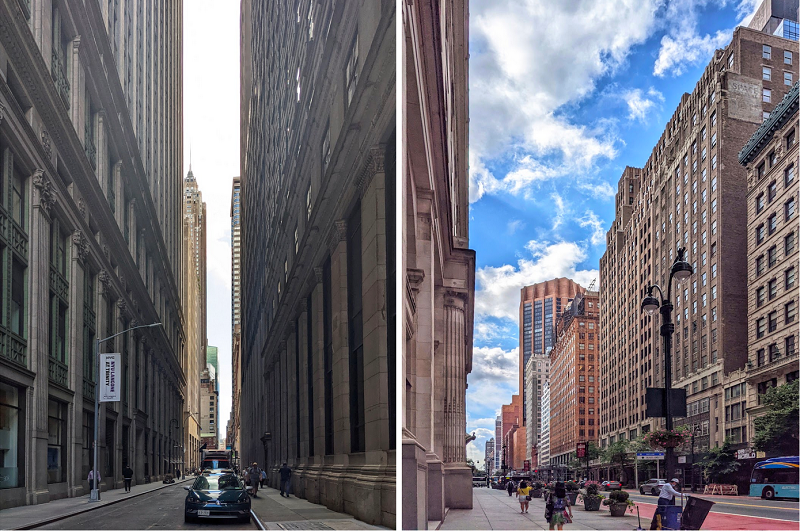
These streets evolved under New York’s famous 1916 building regulations. Before 1916, New York landowners could essentially build as high as they liked, and this did indeed generate streets that were sometimes rather menacing (pictured below left). The 1916 system was designed to allow as much height as possible while preserving the amenity of the street, indexing the height of the buildings to the width of the street and setting back the upper storeys in the time-honoured European fashion (pictured below right). This system lasted until 1961, when it was replaced with modernist regulations designed to generate slab blocks standing on open plazas; the results of this were so obviously inferior that the older system has been partly reinstated.
A pre-1916 street; a post-1916 avenue
My sense is that Manhattan’s tallest 1916-61 streets could not take many more storeys without losing amenity: the regulators basically succeeded in allowing as much height as possible without compromising the public spaces. In a city at a more southerly latitude, where the light is more intense, perhaps a few could be added; and perhaps the avenues could be widened further, with a corresponding growth in the buildings. It is hard to judge imaginary streets. But at any rate, New York shows we can go a lot higher than I had once supposed: there can be great streets with twenty storeys, five or ten more under a light plane, and more again in isolated towers.
And on grid-pattern streets:
Gridiron street plans have been used for planned cities in many times and places — in Harappa, in Dynastic China, in European Antiquity, even in the Middle Ages — so I assume there must be something very good about them. But I have never quite worked out what it is. One annoying thing about gridiron plans is the great frequency of road crossings. Walking the 3.2 miles from the Empire State Building to 1 Wall Street, one must wait, by my count, at 62 traffic lights. Walking the 3.3 miles from the Tower of London to Buckingham Palace, one encounters only 12, along with 8 crossings without lights that probably do not require waiting.
That is a slightly extreme example, but I think frequency of crossings is a general truth about gridirons. A gridiron distributes crossing points evenly and regularly, such that there is no way to reduce the number that one passes. If one wants to go three blocks east and twelve blocks south in Manhattan, there is no way one can avoid traversing fifteen roads. In an organic street plan with an equal overall density of roads, the crossings will be grouped in irregular ways. If one walked randomly, one would average the same number of crossings. But of course people do not walk randomly: one chooses one’s route, with a view in part to reducing the number of roads one has to cross. And so, rather picturesquely, the street plans long called “irrational” are in this respect preferable precisely because they are used by rational creatures.