In the latest issue of his Age of Invention newsletter, Anton Howes considers the innovations that helped provide short-cuts for thought, rather than labour:
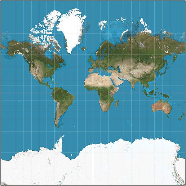
The world on Mercator projection between 85°3’4″S and 85°3’4″N, such that image is square. 15° graticule. Imagery is a derivative of NASA’s Blue Marble summer month composite with oceans lightened to enhance legibility and contrast. Image created with the Geocart map projection software.
Image by Strebe via Wikimedia Commons.
When we think of labour-saving inventions, the kind of labour that springs to mind tends to be manual. We think of machines replacing the muscle of limbs and the dexterity of fingers, and we worry about their effects on unemployment and unrest. But there’s a subset of labour-saving inventions that rarely gets discussed. They might best be called thought-saving.
A few weeks ago I mentioned the introduction of mathematical techniques to navigation. Before the mid-sixteenth century in England, pilots very rarely even knew how to calculate their latitude, let alone their longitude. But over the course of just a few decades, England became one of the world leaders in navigational improvements. A handful of mathematicians saved pilots the trouble of calculation, by coming up with tables, instruments, diagrams, and rules of thumb. In the process, they improved navigation’s accuracy, and ushered in an age of English dominance of the high seas.
The historian Eric H. Ash gives a few great examples. In the 1590s, the explorer John Davis shared a way to calculate the time of high tide, without requiring multiplication. Likewise, William Bourne, a self-taught mathematician and gunner, in the 1560s provided an easy means of calculating the linear distance in one degree of longitude, at any given latitude. He provided a diagram — really an instrument, even if it wasn’t made of wood or brass — which with just a simple piece of string could be used to derive the answer without needing to understand cosines, or really any trigonometry.
The mathematicians did the same with maps, too (after all, aren’t all maps thought-saving?) The sixteenth-century cartographic innovations simplified the pilot’s ability to chart a route, for example by taking away all need to worry about the curvature of the earth. The famous 1560s map projection of Gerardus Mercator stretched the distance between the lines of latitude as they got closer to the poles, so that charting a course on such a map was a simple matter of drawing straight lines rather than complex trigonometry. The Mercator projection may well make Africa look smaller than Greenland — it’s actually almost fifteen times as large — but it made life significantly easier for mariners. For similar reasons, the mathematician John Dee designed a special chart — what he called the “paradoxall compass” — to aid the English explorers who in the 1550s went in search of a northeast and northwest passage to Asia. Conventional charts made navigating high latitudes confusing, as the north pole was a straight line — the map’s top border. Dee’s map made things easier by putting the pole at the centre, as a point, with the lines of latitude as concentric circles.