![]() My weekly column at GuildMag has been posted. This week’s highlight was that pre-purchases started on Tuesday. Everyone who pre-purchases Guild Wars 2 will be able to take part in all the remaining beta events up until formal launch (date not yet nailed down, but definitely in 2012). You also get a three-day head start before the game goes on sale to the general public (only one day if you pre-order rather than pre-purchase). You can buy through the authorized sellers in your region or through the official website.
My weekly column at GuildMag has been posted. This week’s highlight was that pre-purchases started on Tuesday. Everyone who pre-purchases Guild Wars 2 will be able to take part in all the remaining beta events up until formal launch (date not yet nailed down, but definitely in 2012). You also get a three-day head start before the game goes on sale to the general public (only one day if you pre-order rather than pre-purchase). You can buy through the authorized sellers in your region or through the official website.
April 13, 2012
This week in Guild Wars 2
Mapping 18th century shipping patterns
An interesting post at the Guardian on tracing historical shipping patterns:

(Larger version at the original URL)
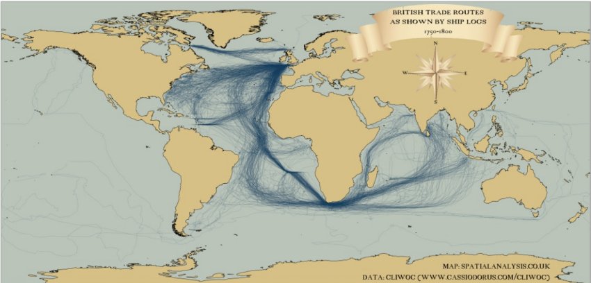
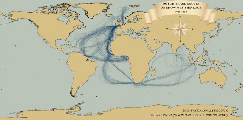
James Cheshire, of Spatial Analysis, has taken historical records of shipping routes between 1750 and 1800 and plotted them using modern mapping tools.
The first map, above, shows journeys made by British ships. Cross-Atlantic shipping lanes were among the busiest, but the number of vessels traveling to what was than called the East Indies — now India and South-East Asia — also stands out when compared to Dutch and Spanish records.
I was surprised to see how many trading voyages there were to and from the Hudson Strait — fur trade traffic, I assume.

(Larger version at the original URL)
This second map shows the same data for Dutch boats. The routes are closely matched to the British ones, although the number of journeys is noticeably smaller.
You can also see the scattering of journeys made by Dutch ships to Svalbard, off the North coast of the Norwegian mainland
Filling in for Envisat: “the CSA’s Radarsats 1 and 2 will try to fill some of the gaps”
The European Space Agency is still at a loss on why their flagship Envisat satellite suddenly went silent, but while they’re trying to diagnose and hopefully fix the problem, the Canadian Space Agency is helping to cover some of the gaps:
Controllers say the eight-tonne spacecraft appears to be in a stable condition, but they are not receiving any data at all from it.
Contact was lost with Envisat at the weekend shortly after it downloaded pictures of Spain’s Canary Islands.
A recovery team, which includes experts from industry, is now trying to re-establish contact with the craft.
Mission managers said on Friday that they were working through a number of possible fault scenarios but conceded they had little to go on.
[. . .]
Of more immediate concern are the operational and scientific projects that rely on Envisat data.
The satellite’s information is used daily to monitor for oil spills at sea, to check on iceberg hazards, and to provide information for meteorological forecasts, among a wide range of services.
All this had now been disrupted, said Prof Liebig.
“What we have done is [activate] the contingency agreement we have with the Canadian Space Agency (CSA) which we have had for many, many years. Canada has responded very positively. So, for a certain time, the CSA’s Radarsats 1 and 2 will try to fill some of the gaps.”


