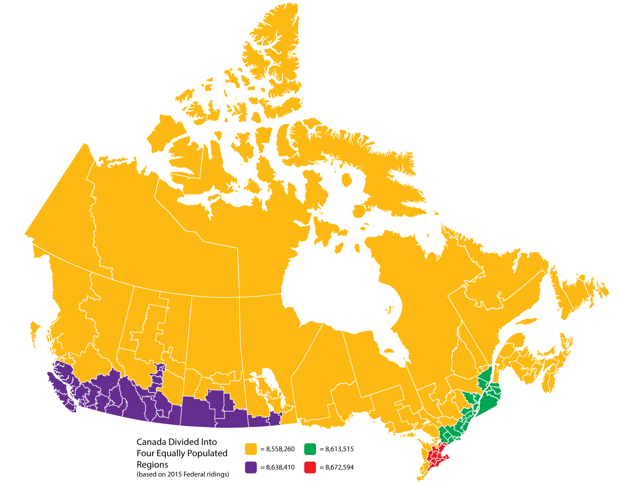
On Reddit, u/the_vizir posted an interesting illustration of Canada divided into four regions of (approximately) equal population, based on the 2015 electoral map:
[Click to see full-size image]
I used this map of Canada’s Federal ridings by DrRandomFactor as a base. Then I attempted to mirror the original map’s divisions, tallying up the populations of the ridings, as based on this chart from Wikipedia.
Ultimately, the original map proved to be rather accurate in the West, but in the East it was off by quite a bit. Despite my best attempts, I could not get the entire Quebec City to Windsor corridor into two geographically contiguous regions. And so Windsor ultimately got shunted into the Great Orange North.
Interestingly, in terms of ridings, the four regions are also rather equal — which one might consider surprising given the population disparity between the largest and smallest ridings (the least populous riding, Labrador, has 27k people; while Brantford-Brant, the most populous, has 132k). However, in the end, the red region has 80 ridings, the green region 83, the purple region 86 and the orange region 89.
The 25 most populous urban areas within that large, orange region include:
- Halifax, NS — 404k
- Windsor, ON — 392k
- St. John’s, NL — 205k
- Barrie, ON — 197k
- Sudbury, ON — 165k
- Saguenay, PQ — 161k
- Moncton, NB — 145k
- Saint John, NB — 126k
- Thunder Bay, ON –121k
- Chatham-Kent, ON — 102k
- Fredericton, NB –102k
- Cape Breton, NS — 99k
- Sarnia, ON – 96k
- Prince George, BC — 86k
- Sault Ste. Marie, ON — 78k
- Fort McMurray. AB — 73k
- North Bay, ON — 70k
- Charlottetown, PE — 69k
- Grande Prairie, AB — 63k
- Rimouski, PQ — 55k
- Shawinigan, PQ — 54k
- Leamington, ON — 49k
- Truro, NS — 46k
- Prince Albert, SK — 44k
- Rouyn-Noranda, PQ — 42k
Somewhat surprisingly, even on this list, no communities in the Territories make the cut. The largest urban area in the North, Whitehorse, is still only 39th on this list, between Fort St. John, BC and Baie-Comeau, PQ. Yellowknife is 48th, between North Battleford, SK and Yorkton, SK.
The smallest riding in the orange area is Charlottetown at 46 sq. km, followed by Windsor West at 83 sq. km and Dartmouth-Cole Harbour at 102 sq. km. The largest riding in one of the other regions is Cypress Hills-Grasslands at 77,822 sq. km, followed by Kootenay-Columbia at 60,405 sq. km and Souris-Moose Mountain at 43,184 sq. km. All of these were in the purple region and were, unfortunately, necessary to bridge Winnipeg to the Calgary-Edmonton corridor, and then the Calgary-Edmonton corridor to the Lower Mainland.
(To those just looking for random facts: the smallest riding of them all is Toronto Centre, at 6 sq. km, followed by Papineau at 10 sq. km and both Laurier-Sainte-Marie and Rosemont-La Petite-Patrie at 11 sq. km each. The largest ones are Nunavut at 2,093,190 sq. km, Northwest Territories at 1,346,106 sq. km and Abitibi-Baie-James-Nunavik-Eeyou at 854,754 sq. km. And no, that last one doesn’t have the longest riding name. That would be Leeds-Grenville-Thousand Islands and Rideau Lakes, coming in at 49 characters and beating out the previous champion, West Vancouver-Sunshine Coast-Sea to Sky Country).
H/T to halls of macademia for the link.