Anton Howes explains something that I’d wondered about in the latest edition of his Age of Invention newsletter:

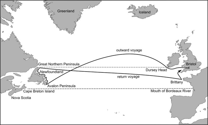
Route of John Cabot’s 1497 voyage on the Matthew of Bristol posited by Jones and Condon: Evan T. Jones and Margaret M. Condon, Cabot and Bristol’s Age of Discovery: The Bristol Discovery Voyages 1480-1508 (University of Bristol, Nov. 2016), fig. 8, p. 43.
Wikimedia Commons.
… in 1550 the English were still struggling with latitude. Their inability to find it, unlike their Spanish and Portuguese rivals, was one of the main things holding them back from voyages of exploration.
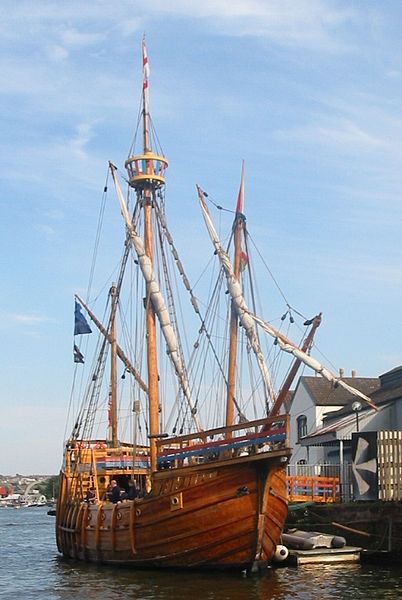
The replica of John Cabot’s ship Matthew in Bristol harbour, adjacent to the SS Great Britain.
Photo by Chris McKenna via Wikimedia Commons.The traditional method of navigation for English pilots was to simply learn the age-old routes. They were trained through repetition and accrued experience, learning to recognise particular landmarks and using a lead and line – just a thin rope weighted with some lead – to determine their location from the depth of the water. Cover the lead with something sticky, and you might bring up some sediment from the sea floor to double-check: a pilot would learn the kinds of sand and pebbles from to expect from different areas. And when they travelled out to sea, away from the coastline, they used a basic system of dead reckoning, taking their compass bearings from a known location, estimating their speed, and keeping in a particular direction for long enough. Or at least hoping to. They might keep track of their progress on a wooden traverse table, inserting pegs to indicate how far they had sailed, but it was ultimately a matter of rough estimation. Should they make any mistake — in terms of their speed, heading, or point of departure — they might easily get lost. But it was still a matter of trying to follow an already-known route. And English mariners of the 1550s did not even know that many routes.
For a voyage of exploration, by contrast, landmarks and sediment from the sea floor would be seen for the first time rather than recalled. By definition, there was no route to follow. So to launch their own voyages of discovery, the English needed to learn a new skill. They needed to look to the heavens.
Celestial navigation — measuring the altitude of heavenly bodies and then using geometry to determine one’s latitude on the earth’s surface — was by the 1550s already hundreds of years old. It had primarily been used to cross the deserts of North Africa and the Middle East — seas of sand, in which there might also be no landmarks from which to take bearings — and to navigate the Indian Ocean. Thus, while pilots in the Atlantic and the Mediterranean stuck to dead reckoning and soundings, Islamic navigators had for centuries used quadrants and astrolabes to take their bearings at sea. By the mid-fifteenth century, these instruments and techniques had found their way to Europe, where they were put to use especially by Portuguese, Spanish, and Italian explorers, along with additional instruments such as the cross-staff.
[…]
So for decades, English explorations relied on foreigners who either knew the routes that the English pilots didn’t, or who at least possessed the skill of mathematical, celestial navigation. The Italian explorer John Cabot (Zuan Chabotto), when he sailed to Newfoundland from Bristol in the late 1490s, was able to take latitude readings (he may even have been familiar with the older Islamic navigational practices, as he claimed to have visited Mecca). When Cabot died, the English expeditions that set out from Bristol in 1501-3 relied on Portuguese pilots from the mid-Atlantic islands of the Azores. And John Cabot’s son, Sebastian Cabot, who was involved in a few English expeditions, was so expert in mathematical navigation that he was eventually appointed pilot major for the entire Spanish Empire, making him responsible for the training and licensing of all its pilots — a position he held for three decades. When he led a voyage of exploration on behalf of Spain in 1526-30, a few English merchants became investors so that they could justify sending with him an English mariner, Roger Barlow, to secretly learn the Spanish routes across the Atlantic and have immediate knowledge if an onward route to Asia was discovered (as it turned out, South America got in the way).


