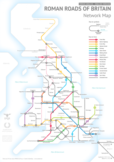
Last month, Colin Marshall shared this post on Open Culture:
Though some of Britain’s Roman Roads have become modern motorways, most no longer exist in any form but those bits and pieces history buffs like to spot. This makes it difficult to get a sense of how they all ran and where — or at least it did until Sasha Trubetskoy made a Roman Roads of Britain Network Map in the graphic-design style of the subway maps you’ll find in London or any other major city today. Trubetskoy, an undergraduate statistics major at the University of Chicago, first found cartographical fame a few months ago with his “subway map” of roads across the entire Roman Empire circa 125 AD.
“Popular request,” he writes, demanded a Britain-specific follow up, a project he describes as “far more complicated than I had initially anticipated.” The challenges included not just the sheer number of Roman Roads in Britain but a lack of clarity about their exact location and extents. As in his previous map, Trubetskoy admits, “I had to do some simplifying and make some tough choices on which cities to include.” While this closer-up view demanded a more geographical faithfulness, he nevertheless “had to get rather creative with the historical evidence” in places, to the point of using such “not exactly Latin-sounding” names as “Watling Street” and “Ermin Way.”


