
Open Culture linked to a fascinating new map by a Swedish grad student, showing trade routes during the Medieval period:
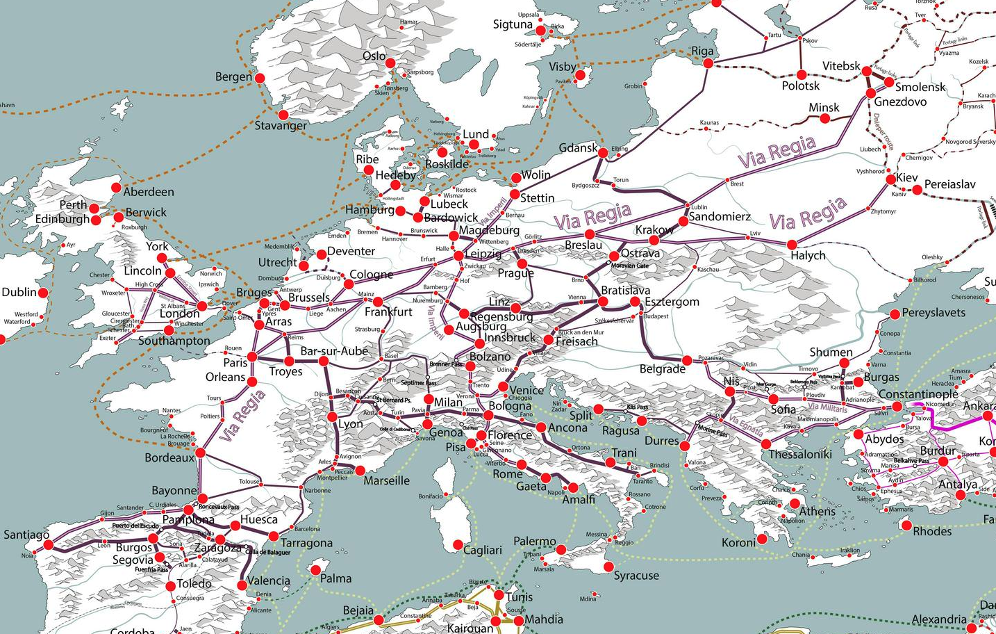
A small portion of Martin Jan Månsson’s trade map of the Middle Ages.
“I think trade routes and topography explains world history in the most concise way,” Månsson explains in the very small print at the map’s lower right corner. “By simply studying the map, one can understand why some areas were especially important–and remained successful even up to modern times.”
The map covers 200 years, spanning both the 11th and 12th centuries, and “depicts the main trading arteries of the high Middle Ages, just after the decline of the Vikings and before the rise of the Mongols, the Hansa and well before the Portuguese rounded the Cape of Good Hope.”
It also shows the complex routes already available to Africa and Asia, and the areas where Muslim and Christian traders would meet. The open-to-trade Song Dynasty ruled China, and the competitive kingdoms in the Indonesia region provided both Muslims and Europeans with spice.
Looking like a railway map, Månsson’s work shows how interconnected we really were back in the Middle Ages, from Greenland in the west to Kikai and Kagoshima in the East, from Arkhangelsk in the frozen north to Sofala in modern-day Mozambique.
The full-sized, high-resolution map can be downloaded here.
Update: Tim Worstall was kind enough to link to this post and uses Månsson’s map to help explain the gravity model of trade:
A standard observation is that places which are closer together trade with each other more than places which are further apart. Add to that the thought that larger economies will trade more with other larger economies – well, you know, more economic activity means more economic activity – and you get the gravity model of trade. So, therefore Britain’s trade future lies with those places nearby, in the EU, than with places further away like the Commonwealth or the US.
This is, sadly, actually the level of debate over Brexit at times. We should trade with France because it’s 26 miles away, so there. The point being that while the gravity model is true – among the best empirically supported of all economic observations – that’s not actually what it says. Rather, that those places which are closer by trade distance trade more with each other. Trade distance being a more complex point than mere geographical location.
[…]
The point here being that by showing the trade routes it is showing us this trade, or perhaps economic, distance which is what the gravity model is about. Valencia and Palma were very much closer – and trade very much more – than Valencia and Toledo, despite roughly equal distances crowfly wise.

[…] At which point this lovely map. […]
Pingback by To Explain That Gravity Model Of Trade For You | The Continental Telegraph — July 1, 2018 @ 07:10